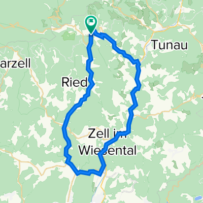
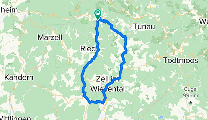
Mittlere WiesentÀler-Runde
A cycling route starting in Böllen, Baden-Wurttemberg, Germany.
Overview
About this route
Von Neuenweg das kleine Wiesental runter nach Wieslet, das groĂe hoch nach Membach und ĂŒber Böllen zurĂŒck.
- -:--
- Duration
- 38.8 km
- Distance
- 858 m
- Ascent
- 857 m
- Descent
- ---
- Avg. speed
- 820 m
- Max. altitude
Route quality
Waytypes & surfaces along the route
Waytypes
Busy road
17.1 km
(44 %)
Quiet road
8.8 km
(23 %)
Surfaces
Paved
16 km
(41 %)
Unpaved
8.2 km
(21 %)
Asphalt
12.9 km
(33 %)
Gravel
5.7 km
(15 %)
Continue with Bikemap
Use, edit, or download this cycling route
You would like to ride Mittlere WiesentÀler-Runde or customize it for your own trip? Here is what you can do with this Bikemap route:
Free features
- Save this route as favorite or in collections
- Copy & plan your own version of this route
- Sync your route with Garmin or Wahoo
Premium features
Free trial for 3 days, or one-time payment. More about Bikemap Premium.
- Navigate this route on iOS & Android
- Export a GPX / KML file of this route
- Create your custom printout (try it for free)
- Download this route for offline navigation
Discover more Premium features.
Get Bikemap PremiumFrom our community
Other popular routes starting in Böllen
- Belchen-WiedenerEck-Feldberg
- Distance
- 29.7 km
- Ascent
- 801 m
- Descent
- 487 m
- Location
- Böllen, Baden-Wurttemberg, Germany
- Belchen roundweg
- Distance
- 1.2 km
- Ascent
- 65 m
- Descent
- 65 m
- Location
- Böllen, Baden-Wurttemberg, Germany
- Test Belchen
- Distance
- 2.5 km
- Ascent
- 264 m
- Descent
- 186 m
- Location
- Böllen, Baden-Wurttemberg, Germany
- Nonnenmattweiher
- Distance
- 14.8 km
- Ascent
- 436 m
- Descent
- 534 m
- Location
- Böllen, Baden-Wurttemberg, Germany
- Belchen - Stohren - Schauinsland - Gundelfingen
- Distance
- 46.5 km
- Ascent
- 1,363 m
- Descent
- 2,393 m
- Location
- Böllen, Baden-Wurttemberg, Germany
- Kleine WiesentÀler-Runde
- Distance
- 35.3 km
- Ascent
- 937 m
- Descent
- 934 m
- Location
- Böllen, Baden-Wurttemberg, Germany
- Langlaufroute-Kreuzweg-Lipple-Gleichen-Kreuzweg
- Distance
- 27.7 km
- Ascent
- 598 m
- Descent
- 598 m
- Location
- Böllen, Baden-Wurttemberg, Germany
- BĂŒrchau-Belchen-Nonnenmattweiher
- Distance
- 35.5 km
- Ascent
- 1,185 m
- Descent
- 1,185 m
- Location
- Böllen, Baden-Wurttemberg, Germany
Open it in the app