

Omaha to Bayeux
A cycling route starting in Port-en-Bessin-Huppain, Normandy, France.
Overview
About this route
This short day allows us a whole afternoon in Bayeux
- -:--
- Duration
- 21 km
- Distance
- 171 m
- Ascent
- 188 m
- Descent
- ---
- Avg. speed
- 66 m
- Max. altitude

Route quality
Waytypes & surfaces along the route
Waytypes
Quiet road
11.2 km
(53 %)
Road
4.4 km
(21 %)
Surfaces
Paved
10.5 km
(50 %)
Unpaved
1.7 km
(8 %)
Asphalt
10.5 km
(50 %)
Gravel
1.7 km
(8 %)
Undefined
8.8 km
(42 %)
Route highlights
Points of interest along the route
Point of interest after 0 km
Overlord museum
Point of interest after 0 km
American cemetery
Point of interest after 15.8 km
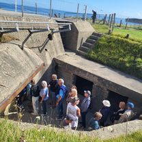
Longues sur Mer German battery emplacement
Point of interest after 19.7 km
Bayeux Memorial
Point of interest after 21 km
Bayeux Tapestry
Continue with Bikemap
Use, edit, or download this cycling route
You would like to ride Omaha to Bayeux or customize it for your own trip? Here is what you can do with this Bikemap route:
Free features
- Save this route as favorite or in collections
- Copy & plan your own version of this route
- Sync your route with Garmin or Wahoo
Premium features
Free trial for 3 days, or one-time payment. More about Bikemap Premium.
- Navigate this route on iOS & Android
- Export a GPX / KML file of this route
- Create your custom printout (try it for free)
- Download this route for offline navigation
Discover more Premium features.
Get Bikemap PremiumFrom our community
Other popular routes starting in Port-en-Bessin-Huppain
 Port en Bessin bis Isigny
- Distance
- 53.6 km
- Ascent
- 351 m
- Descent
- 382 m
- Location
- Port-en-Bessin-Huppain, Normandy, France
 Omaha to Bayeux
- Distance
- 21 km
- Ascent
- 171 m
- Descent
- 188 m
- Location
- Port-en-Bessin-Huppain, Normandy, France
 Bayeaux - Domaine Airborne
- Distance
- 66 km
- Ascent
- 199 m
- Descent
- 191 m
- Location
- Port-en-Bessin-Huppain, Normandy, France
 Rue Maréchal de Tourville nach Rue Maréchal de Tourville
- Distance
- 26.5 km
- Ascent
- 250 m
- Descent
- 290 m
- Location
- Port-en-Bessin-Huppain, Normandy, France
 From Port-en-Bessin-Huppain to Ouistreham
- Distance
- 59.3 km
- Ascent
- 205 m
- Descent
- 255 m
- Location
- Port-en-Bessin-Huppain, Normandy, France
 commes pointe du hoc
- Distance
- 47.6 km
- Ascent
- 287 m
- Descent
- 287 m
- Location
- Port-en-Bessin-Huppain, Normandy, France
 From Port-en-Bessin-Huppain to Ouistreham 02
- Distance
- 61.4 km
- Ascent
- 212 m
- Descent
- 260 m
- Location
- Port-en-Bessin-Huppain, Normandy, France
 Tag 22: Normandie 3
- Distance
- 56.3 km
- Ascent
- 405 m
- Descent
- 404 m
- Location
- Port-en-Bessin-Huppain, Normandy, France
Open it in the app