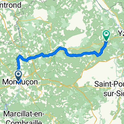
part 5
A cycling route starting in Montlu莽on, Auvergne-Rh么ne-Alpes, France.
Overview
About this route
- -:--
- Duration
- 286.8 km
- Distance
- 2,553 m
- Ascent
- 2,624 m
- Descent
- ---
- Avg. speed
- 610 m
- Avg. speed
Route quality
Waytypes & surfaces along the route
Waytypes
Busy road
193.3 km
(67 %)
Quiet road
43.5 km
(15 %)
Surfaces
Paved
133 km
(46 %)
Unpaved
2.9 km
(1 %)
Asphalt
132.5 km
(46 %)
Gravel
2.9 km
(1 %)
Route highlights
Points of interest along the route
Point of interest after 129.7 km
Point of interest after 283.7 km
Continue with Bikemap
Use, edit, or download this cycling route
You would like to ride part 5 or customize it for your own trip? Here is what you can do with this Bikemap route:
Free features
- Save this route as favorite or in collections
- Copy & plan your own version of this route
- Sync your route with Garmin or Wahoo
Premium features
Free trial for 3 days, or one-time payment. More about Bikemap Premium.
- Navigate this route on iOS & Android
- Export a GPX / KML file of this route
- Create your custom printout (try it for free)
- Download this route for offline navigation
Discover more Premium features.
Get Bikemap PremiumFrom our community
Other popular routes starting in Montlu莽on
- 150 - 05 - Montlucon - La Banne d'Ordanche
- Distance
- 205.9 km
- Ascent
- 3,469 m
- Descent
- 2,371 m
- Location
- Montlu莽on, Auvergne-Rh么ne-Alpes, France
- 5掳 rit naar Tourmalet
- Distance
- 143.6 km
- Ascent
- 1,165 m
- Descent
- 755 m
- Location
- Montlu莽on, Auvergne-Rh么ne-Alpes, France
- [Tour Francia 2001 - Et. 18] CRI: Montlu莽on - Saint-Amand-Montrond
- Distance
- 62.3 km
- Ascent
- 466 m
- Descent
- 473 m
- Location
- Montlu莽on, Auvergne-Rh么ne-Alpes, France
- Montlucon-Liourdres-Gourdon
- Distance
- 364.7 km
- Ascent
- 1,792 m
- Descent
- 1,756 m
- Location
- Montlu莽on, Auvergne-Rh么ne-Alpes, France
- part 5
- Distance
- 286.8 km
- Ascent
- 2,553 m
- Descent
- 2,624 m
- Location
- Montlu莽on, Auvergne-Rh么ne-Alpes, France
- 18 猫me 茅tape : Montlu莽on - Saint-Amand-Montrond 61 km contre-la-montre
- Distance
- 61.1 km
- Ascent
- 355 m
- Descent
- 407 m
- Location
- Montlu莽on, Auvergne-Rh么ne-Alpes, France
- Trek July 2020
- Distance
- 708.5 km
- Ascent
- 3,722 m
- Descent
- 3,713 m
- Location
- Montlu莽on, Auvergne-Rh么ne-Alpes, France
- Tour de France Etape 6: Montlu莽on - Aubusson
- Distance
- 202.4 km
- Ascent
- 1,358 m
- Descent
- 1,032 m
- Location
- Montlu莽on, Auvergne-Rh么ne-Alpes, France
Open it in the app