
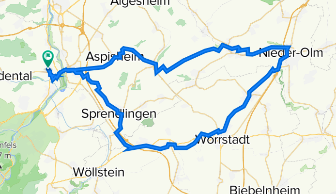
Lalo-NiederOlm-Lalo
A cycling route starting in Langenlonsheim, Rhineland-Palatinate, Germany.
Overview
About this route
Lalo-OberHilbersheim-NiederOlm-Wörstadt-GauBickelheim-Sprendlingen-Lalo
- -:--
- Duration
- 65.5 km
- Distance
- 482 m
- Ascent
- 484 m
- Descent
- ---
- Avg. speed
- 265 m
- Max. altitude

Route quality
Waytypes & surfaces along the route
Waytypes
Track
21 km
(32 %)
Quiet road
13.1 km
(20 %)
Surfaces
Paved
54.4 km
(83 %)
Unpaved
0.7 km
(1 %)
Asphalt
40 km
(61 %)
Paved (undefined)
11.8 km
(18 %)
Continue with Bikemap
Use, edit, or download this cycling route
You would like to ride Lalo-NiederOlm-Lalo or customize it for your own trip? Here is what you can do with this Bikemap route:
Free features
- Save this route as favorite or in collections
- Copy & plan your own version of this route
- Sync your route with Garmin or Wahoo
Premium features
Free trial for 3 days, or one-time payment. More about Bikemap Premium.
- Navigate this route on iOS & Android
- Export a GPX / KML file of this route
- Create your custom printout (try it for free)
- Download this route for offline navigation
Discover more Premium features.
Get Bikemap PremiumFrom our community
Other popular routes starting in Langenlonsheim
 Lalo - Münchberg - Gräfenbachtal - Lalo
- Distance
- 48.1 km
- Ascent
- 764 m
- Descent
- 766 m
- Location
- Langenlonsheim, Rhineland-Palatinate, Germany
 Lalo - Niederheimbach(Rhein) - Jägerhaus(BIN-Wald) - Stromberg - Lalo
- Distance
- 54.2 km
- Ascent
- 697 m
- Descent
- 696 m
- Location
- Langenlonsheim, Rhineland-Palatinate, Germany
 Hunsrück1
- Distance
- 86.1 km
- Ascent
- 1,167 m
- Descent
- 1,058 m
- Location
- Langenlonsheim, Rhineland-Palatinate, Germany
 Lalo - Schanzerkopf - Lalo
- Distance
- 64.8 km
- Ascent
- 1,001 m
- Descent
- 1,000 m
- Location
- Langenlonsheim, Rhineland-Palatinate, Germany
 Lalo-NiederOlm-Lalo
- Distance
- 65.5 km
- Ascent
- 482 m
- Descent
- 484 m
- Location
- Langenlonsheim, Rhineland-Palatinate, Germany
 Lalo-KH-Hackenheim-Frei-Laubersheim-Tiefental-Kalkofen-Hochstätten-BadMünster-KH-Lalo
- Distance
- 56.7 km
- Ascent
- 531 m
- Descent
- 533 m
- Location
- Langenlonsheim, Rhineland-Palatinate, Germany
 Sykwalk
- Distance
- 94.8 km
- Ascent
- 732 m
- Descent
- 735 m
- Location
- Langenlonsheim, Rhineland-Palatinate, Germany
 Soonwaldtour
- Distance
- 93.6 km
- Ascent
- 1,119 m
- Descent
- 1,119 m
- Location
- Langenlonsheim, Rhineland-Palatinate, Germany
Open it in the app