

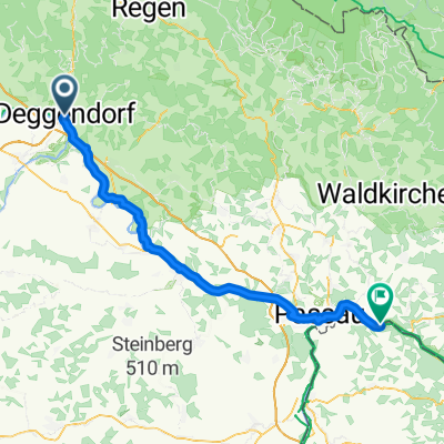
Donau-Radweg: Deggendorf – Passau CLONED FROM ROUTE 66
A cycling route starting in Deggendorf, Bavaria, Germany.
Overview
About this route
Diese Etappe fährt man zunächst am Kloster Niederaltaich vorbei, das im Laufe der Jahrhunderte dreizehnmal in Flammen stand. Weiter geht die Fahrt in das historische Städtchen Vilshofen, berühmt geworden durch die Aschermittwochsreden des CSU-Vorsitzenden Strauss. Bald erreicht man die Drei-Flüsse-Stadt und ehemalige Bischofsresidenz Passau. Hier kann man die Donau, Inn und Ilz per Schiff erkunden, sowie die Altstadt bei einem Spaziergang.
- -:--
- Duration
- 65.4 km
- Distance
- 90 m
- Ascent
- 105 m
- Descent
- ---
- Avg. speed
- ---
- Max. altitude
Route quality
Waytypes & surfaces along the route
Waytypes
Quiet road
29.4 km
(45 %)
Track
14.4 km
(22 %)
Surfaces
Paved
37.3 km
(57 %)
Unpaved
11.1 km
(17 %)
Asphalt
37.3 km
(57 %)
Loose gravel
5.2 km
(8 %)
Continue with Bikemap
Use, edit, or download this cycling route
You would like to ride Donau-Radweg: Deggendorf – Passau CLONED FROM ROUTE 66 or customize it for your own trip? Here is what you can do with this Bikemap route:
Free features
- Save this route as favorite or in collections
- Copy & plan your own version of this route
- Sync your route with Garmin or Wahoo
Premium features
Free trial for 3 days, or one-time payment. More about Bikemap Premium.
- Navigate this route on iOS & Android
- Export a GPX / KML file of this route
- Create your custom printout (try it for free)
- Download this route for offline navigation
Discover more Premium features.
Get Bikemap PremiumFrom our community
Other popular routes starting in Deggendorf
 Ruseltour
- Distance
- 60.3 km
- Ascent
- 928 m
- Descent
- 928 m
- Location
- Deggendorf, Bavaria, Germany
 Deggendorf - Tegernheim
- Distance
- 83.3 km
- Ascent
- 155 m
- Descent
- 132 m
- Location
- Deggendorf, Bavaria, Germany
 Niederwinkling - Passau
- Distance
- 70.4 km
- Ascent
- 186 m
- Descent
- 212 m
- Location
- Deggendorf, Bavaria, Germany
 From Deggendorf to Landshut
- Distance
- 85.9 km
- Ascent
- 437 m
- Descent
- 360 m
- Location
- Deggendorf, Bavaria, Germany
 Offenberg - Schärding
- Distance
- 59 km
- Ascent
- 145 m
- Descent
- 152 m
- Location
- Deggendorf, Bavaria, Germany
 Deggendorf - Lindberg
- Distance
- 49.8 km
- Ascent
- 1,219 m
- Descent
- 922 m
- Location
- Deggendorf, Bavaria, Germany
 Winzer - Atzesberg
- Distance
- 58.5 km
- Ascent
- 149 m
- Descent
- 166 m
- Location
- Deggendorf, Bavaria, Germany
 W-07_Deggendorf-Passau_89km
- Distance
- 88.9 km
- Ascent
- 194 m
- Descent
- 208 m
- Location
- Deggendorf, Bavaria, Germany
Open it in the app