

RSC Tannheimer Tal 2022
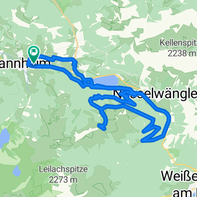
RSC TTal - Stuibenalpe kurz
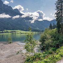
A cycling route starting in Tannheim, Tyrol, Austria.
Overview
About this route
20km / 410Hm
Break at Stubenalpe at km 12
- -:--
- Duration
- 20.4 km
- Distance
- 1,415 m
- Ascent
- 1,415 m
- Descent
- ---
- Avg. speed
- 1,417 m
- Max. altitude

Part of
RSC Tannheimer Tal 2022
11 stages
Route quality
Waytypes & surfaces along the route
Waytypes
Track
14.5 km
(71 %)
Access road
3.5 km
(17 %)
Surfaces
Paved
14.7 km
(72 %)
Unpaved
3.7 km
(18 %)
Paved (undefined)
7.5 km
(37 %)
Asphalt
7.1 km
(35 %)
Continue with Bikemap
Use, edit, or download this cycling route
You would like to ride RSC TTal - Stuibenalpe kurz or customize it for your own trip? Here is what you can do with this Bikemap route:
Free features
- Save this route as favorite or in collections
- Copy & plan your own version of this route
- Sync your route with Garmin or Wahoo
Premium features
Free trial for 3 days, or one-time payment. More about Bikemap Premium.
- Navigate this route on iOS & Android
- Export a GPX / KML file of this route
- Create your custom printout (try it for free)
- Download this route for offline navigation
Discover more Premium features.
Get Bikemap PremiumFrom our community
Other popular routes starting in Tannheim
 Tour 2013 Namlosrunde Schwierigkeitsgrad mittel
- Distance
- 74.5 km
- Ascent
- 947 m
- Descent
- 951 m
- Location
- Tannheim, Tyrol, Austria
 Vorarlbergrunde
- Distance
- 166.2 km
- Ascent
- 2,190 m
- Descent
- 2,190 m
- Location
- Tannheim, Tyrol, Austria
 Tour 2013 Auf König LudwigsSpuren mittel
- Distance
- 69.8 km
- Ascent
- 666 m
- Descent
- 666 m
- Location
- Tannheim, Tyrol, Austria
 Radltour in Tannheim
- Distance
- 50.8 km
- Ascent
- 289 m
- Descent
- 513 m
- Location
- Tannheim, Tyrol, Austria
 Tour Strinden Alpe
- Distance
- 23.7 km
- Ascent
- 948 m
- Descent
- 948 m
- Location
- Tannheim, Tyrol, Austria
 Tannheim-Pronten-Reutte-Berwang-Namlos-Tannheim
- Distance
- 105 km
- Ascent
- 1,011 m
- Descent
- 1,012 m
- Location
- Tannheim, Tyrol, Austria
 Tannheimer Tal - Radmarathon
- Distance
- 225.8 km
- Ascent
- 2,320 m
- Descent
- 2,321 m
- Location
- Tannheim, Tyrol, Austria
 Tannheim-Haldensee
- Distance
- 35.6 km
- Ascent
- 726 m
- Descent
- 726 m
- Location
- Tannheim, Tyrol, Austria
Open it in the app