

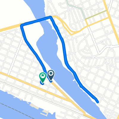
Calle Bella Vista 113, Tampico a Avenida Miguel Hidalgo y Costilla 282–384, Tampico
A cycling route starting in Anahuac, Veracruz, Mexico.
Overview
About this route
- 31 min
- Duration
- 6.1 km
- Distance
- 36 m
- Ascent
- 30 m
- Descent
- 11.8 km/h
- Avg. speed
- 19 m
- Max. altitude
Route quality
Waytypes & surfaces along the route
Waytypes
Quiet road
3.7 km
(60 %)
Road
2.4 km
(39 %)
Surfaces
Paved
0.1 km
(<1 %)
Concrete
0.1 km
(<1 %)
Undefined
6 km
(99 %)
Continue with Bikemap
Use, edit, or download this cycling route
You would like to ride Calle Bella Vista 113, Tampico a Avenida Miguel Hidalgo y Costilla 282–384, Tampico or customize it for your own trip? Here is what you can do with this Bikemap route:
Free features
- Save this route as favorite or in collections
- Copy & plan your own version of this route
- Sync your route with Garmin or Wahoo
Premium features
Free trial for 3 days, or one-time payment. More about Bikemap Premium.
- Navigate this route on iOS & Android
- Export a GPX / KML file of this route
- Create your custom printout (try it for free)
- Download this route for offline navigation
Discover more Premium features.
Get Bikemap PremiumFrom our community
Other popular routes starting in Anahuac
 De Salvador Díaz Mirón 108, Tampico a Blvd. Costero SN-S RESTAURANT BAR EL HUACHINANGO, Ciudad Madero
- Distance
- 11.2 km
- Ascent
- 68 m
- Descent
- 79 m
- Location
- Anahuac, Veracruz, Mexico
 De Calle Francisco Medina Cedillo 302–306, Tampico a Boulevard Licenciado Adolfo López Mateos 2450, Tampico
- Distance
- 27.9 km
- Ascent
- 160 m
- Descent
- 172 m
- Location
- Anahuac, Veracruz, Mexico
 gordo 1
- Distance
- 5.4 km
- Ascent
- 57 m
- Descent
- 42 m
- Location
- Anahuac, Veracruz, Mexico
 mandaditos 1
- Distance
- 1.3 km
- Ascent
- 37 m
- Descent
- 12 m
- Location
- Anahuac, Veracruz, Mexico
 gordo hahaha
- Distance
- 2.9 km
- Ascent
- 26 m
- Descent
- 9 m
- Location
- Anahuac, Veracruz, Mexico
 trabajooo
- Distance
- 4.3 km
- Ascent
- 61 m
- Descent
- 23 m
- Location
- Anahuac, Veracruz, Mexico
 Entrenamiento subidas
- Distance
- 39.9 km
- Ascent
- 330 m
- Descent
- 330 m
- Location
- Anahuac, Veracruz, Mexico
 De Faja de Oro 61, Hidalgo a Agua Dulce, Benito Juárez
- Distance
- 1.6 km
- Ascent
- 28 m
- Descent
- 0 m
- Location
- Anahuac, Veracruz, Mexico
Open it in the app