NPL *Dag 9 ( Totalt 206,575km )
- 206.6 km
- 535 m
- 533 m
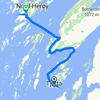
- Vevelstad, Nordland, Norway
A cycling route starting in Vevelstad, Nordland, Norway.
Overview
Cycle 15.4km to Andalsvåg ferry, 28km to Torghatten
created this 3 years ago
Route quality
Cycleway
8.7 km
(18 %)
Pedestrian area
1.9 km
(4 %)
Paved
40.3 km
(83 %)
Asphalt
40.3 km
(83 %)
Undefined
8.2 km
(17 %)
Route highlights
Handelsstedet Forvik
Vevelstad Gård og Rorbuer
Vevelstad Rorbuer Sigrid und Ole
Vevelstad Gjestegård og Rorbuer
Andalsvåg - Horn Ferry 20 min Off season timetable shown M-F: 0625 0730 0915 1005 1140 1230 1420 1510 1635 1730 1950 2150 2240 Sa: 0820 0915 1005 1230 1420 1655 1950 2150 2240 Su: 0915 1005 1230 1420 1510 1635 1730 1950 2150 2240
Skarsåsen festningsanlegg Freely accessible WWII facility, tunnels
Thon Hotel
Brønnøy Church
Brønnøysund brua
Salmon Fishing Centre and Restaurant/Accommodation

Torghatten National reserve Short walk and stunning views.
Torget Camping Accommodation & Restaurant
Torgarhaugen
Continue with Bikemap
You would like to ride 70. Vevelstad to Torghatten or customize it for your own trip? Here is what you can do with this Bikemap route:
Free trial for 3 days, or one-time payment. More about Bikemap Premium.
Discover more Premium features.
Get Bikemap PremiumFrom our community
Open it in the app