

Magyarország Hegyei
Magyarország Hegyei 9. szakasz
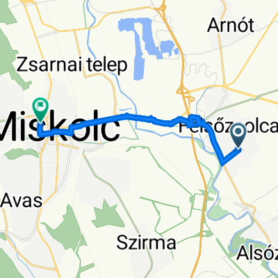
A cycling route starting in Felsőzsolca, Borsod-Abauj Zemplen county, Hungary.
Overview
About this route
Abaúj-Zemplén
- -:--
- Duration
- 121.4 km
- Distance
- 1,395 m
- Ascent
- 1,349 m
- Descent
- ---
- Avg. speed
- 896 m
- Max. altitude

Part of
Magyarország Hegyei
9 stages
Route quality
Waytypes & surfaces along the route
Waytypes
Quiet road
25.5 km
(21 %)
Track
7.3 km
(6 %)
Surfaces
Paved
26.7 km
(22 %)
Unpaved
4.9 km
(4 %)
Asphalt
26.7 km
(22 %)
Rock
3.6 km
(3 %)
Route highlights
Points of interest along the route
Point of interest after 91.7 km
Nagy-Milic (894 m)
Continue with Bikemap
Use, edit, or download this cycling route
You would like to ride Magyarország Hegyei 9. szakasz or customize it for your own trip? Here is what you can do with this Bikemap route:
Free features
- Save this route as favorite or in collections
- Copy & plan your own version of this route
- Split it into stages to create a multi-day tour
- Sync your route with Garmin or Wahoo
Premium features
Free trial for 3 days, or one-time payment. More about Bikemap Premium.
- Navigate this route on iOS & Android
- Export a GPX / KML file of this route
- Create your custom printout (try it for free)
- Download this route for offline navigation
Discover more Premium features.
Get Bikemap PremiumFrom our community
Other popular routes starting in Felsőzsolca
 Decathlon-Hell
- Distance
- 93.1 km
- Ascent
- 253 m
- Descent
- 246 m
- Location
- Felsőzsolca, Borsod-Abauj Zemplen county, Hungary
 day 11 fuzesabony
- Distance
- 66.5 km
- Ascent
- 58 m
- Descent
- 55 m
- Location
- Felsőzsolca, Borsod-Abauj Zemplen county, Hungary
 Arany János utca 2/2., Felsőzsolca to Horváth Lajos utca 2., Miskolc
- Distance
- 8 km
- Ascent
- 25 m
- Descent
- 9 m
- Location
- Felsőzsolca, Borsod-Abauj Zemplen county, Hungary
 MC - Onga
- Distance
- 6.6 km
- Ascent
- 76 m
- Descent
- 87 m
- Location
- Felsőzsolca, Borsod-Abauj Zemplen county, Hungary
 Fonoda utca 54., Miskolc to Fonoda utca 56., Miskolc
- Distance
- 3.4 km
- Ascent
- 0 m
- Descent
- 0 m
- Location
- Felsőzsolca, Borsod-Abauj Zemplen county, Hungary
 Hősök tere 26, Felsőzsolca to Hősök tere 26, Felsőzsolca
- Distance
- 13 km
- Ascent
- 60 m
- Descent
- 61 m
- Location
- Felsőzsolca, Borsod-Abauj Zemplen county, Hungary
 Felsőzsolca, Szent István u., Miskolc to Unnamed Road, Miskolc
- Distance
- 22 km
- Ascent
- 232 m
- Descent
- 66 m
- Location
- Felsőzsolca, Borsod-Abauj Zemplen county, Hungary
 Auchan - Onga
- Distance
- 7 km
- Ascent
- 93 m
- Descent
- 85 m
- Location
- Felsőzsolca, Borsod-Abauj Zemplen county, Hungary
Open it in the app