Brugg - Rheinfelden
A cycling route starting in Lauffohr (Brugg), Canton of Aargau, Switzerland.
Overview
About this route
Route 56 und Internat. Route 2 von Brugg Richtung Rheinfelden.
Nicht für das Rennrad geeignet ;)
- -:--
- Duration
- 50 km
- Distance
- 344 m
- Ascent
- 424 m
- Descent
- ---
- Avg. speed
- ---
- Avg. speed
Route quality
Waytypes & surfaces along the route
Waytypes
Quiet road
18.2 km
(36 %)
Track
15.4 km
(31 %)
Surfaces
Paved
34.9 km
(70 %)
Unpaved
10.4 km
(21 %)
Asphalt
33.6 km
(67 %)
Gravel
9.7 km
(19 %)
Continue with Bikemap
Use, edit, or download this cycling route
You would like to ride Brugg - Rheinfelden or customize it for your own trip? Here is what you can do with this Bikemap route:
Free features
- Save this route as favorite or in collections
- Copy & plan your own version of this route
- Sync your route with Garmin or Wahoo
Premium features
Free trial for 3 days, or one-time payment. More about Bikemap Premium.
- Navigate this route on iOS & Android
- Export a GPX / KML file of this route
- Create your custom printout (try it for free)
- Download this route for offline navigation
Discover more Premium features.
Get Bikemap PremiumFrom our community
Other popular routes starting in Lauffohr (Brugg)
- Schlussetappe Siggenthal-Menziken
- Distance
- 46.2 km
- Ascent
- 461 m
- Descent
- 226 m
- Location
- Lauffohr (Brugg), Canton of Aargau, Switzerland
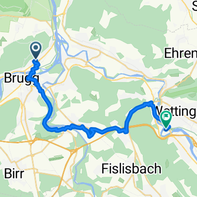
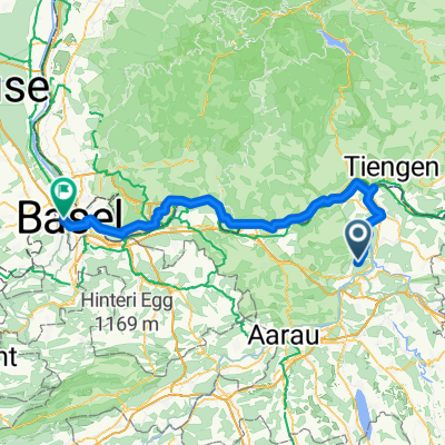
- Wiederhergestellte Route
- Distance
- 32.9 km
- Ascent
- 339 m
- Descent
- 339 m
- Location
- Lauffohr (Brugg), Canton of Aargau, Switzerland
- lap flat
- Distance
- 26.7 km
- Ascent
- 113 m
- Descent
- 101 m
- Location
- Lauffohr (Brugg), Canton of Aargau, Switzerland
- Ruine Besserstein- Sennhütte- Linner Wasserfall- Ruine Schenkenberg
- Distance
- 49.1 km
- Ascent
- 1,032 m
- Descent
- 1,026 m
- Location
- Lauffohr (Brugg), Canton of Aargau, Switzerland
- Rund um Brugg
- Distance
- 29.8 km
- Ascent
- 201 m
- Descent
- 201 m
- Location
- Lauffohr (Brugg), Canton of Aargau, Switzerland
- Mellingen-Brugg
- Distance
- 14.5 km
- Ascent
- 93 m
- Descent
- 168 m
- Location
- Lauffohr (Brugg), Canton of Aargau, Switzerland
- AG Stilli Sulz Klingnau Stilli
- Distance
- 49.8 km
- Ascent
- 852 m
- Descent
- 854 m
- Location
- Lauffohr (Brugg), Canton of Aargau, Switzerland
- Brugg - Rheinfelden
- Distance
- 50 km
- Ascent
- 344 m
- Descent
- 424 m
- Location
- Lauffohr (Brugg), Canton of Aargau, Switzerland
Open it in the app