

Carpathian peaks. Route 3. Rokyta-Makovytsia.
A cycling route starting in Yaremche, Ivano-Frankivsk Oblast, Ukraine.
Overview
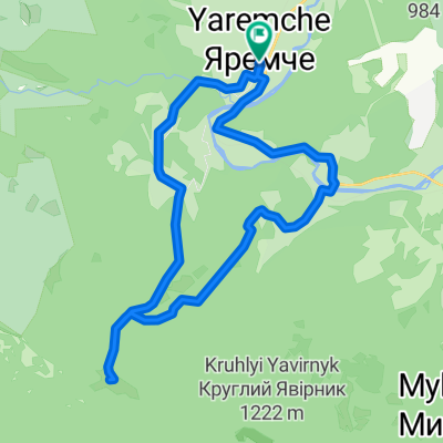
About this route
<span style="mso-fareast-font-family: "Times New Roman"; mso-bidi-font-family: "Times New Roman"; color: black; mso-ansi-language: EN-US; mso-fareast-language: RU;" lang="EN-US">The route starts at the bridge of the Prutets river which impresses by its beauty. Along the river canyon we head to Kostel rocks and then go up to Rokyta mountain. On the top we make fabulous pictures and through the mountain meadows head to Makovytsia mountain, then go down to Yamna and come back to the place of our accommodation. </span>
<span style="mso-fareast-font-family: "Times New Roman"; mso-bidi-font-family: "Times New Roman"; color: black; mso-themecolor: text1; mso-ansi-language: EN-US; mso-fareast-language: RU;" lang="EN-US"> </span>
<span style="mso-fareast-font-family: "Times New Roman"; mso-bidi-font-family: "Times New Roman"; color: black; mso-themecolor: text1; mso-ansi-language: EN-US; mso-fareast-language: RU;" lang="EN-US">Sights of the day</span>
<span style="font-family: Symbol; mso-fareast-font-family: Symbol; mso-bidi-font-family: Symbol; color: black; mso-ansi-language: EN-US; mso-fareast-language: RU;" lang="EN-US"><span style="mso-list: Ignore;">·<span style="font: 7.0pt "Times New Roman";"> </span></span></span><span style="mso-fareast-font-family: "Times New Roman"; mso-bidi-font-family: "Times New Roman"; color: black; mso-ansi-language: EN-US; mso-fareast-language: RU;" lang="EN-US">Kostel mountain in the form of the huge rock.</span>
<span style="font-family: Symbol; mso-fareast-font-family: Symbol; mso-bidi-font-family: Symbol; color: black; mso-ansi-language: EN-US; mso-fareast-language: RU;" lang="EN-US"><span style="mso-list: Ignore;">·<span style="font: 7.0pt "Times New Roman";"> </span></span></span><span style="mso-fareast-font-family: "Times New Roman"; mso-bidi-font-family: "Times New Roman"; color: black; mso-ansi-language: EN-US; mso-fareast-language: RU;" lang="EN-US">Rokyta mountain. When the weather is good you may see almost half of Hutsulshchyna from the top as well as famous city Ivano-Frankivsk.</span>
<span style="font-family: Symbol; mso-fareast-font-family: Symbol; mso-bidi-font-family: Symbol; color: black; mso-ansi-language: EN-US; mso-fareast-language: RU;" lang="EN-US"><span style="mso-list: Ignore;">·<span style="font: 7.0pt "Times New Roman";"> </span></span></span><span style="mso-fareast-font-family: "Times New Roman"; mso-bidi-font-family: "Times New Roman"; color: black; mso-ansi-language: EN-US; mso-fareast-language: RU;" lang="EN-US">Makovytsia mountain. Here you will see a number of trenches from the times of World War I and World War II.</span>
- -:--
- Duration
- 34.6 km
- Distance
- 802 m
- Ascent
- 804 m
- Descent
- ---
- Avg. speed
- ---
- Max. altitude

Continue with Bikemap
Use, edit, or download this cycling route
You would like to ride Carpathian peaks. Route 3. Rokyta-Makovytsia. or customize it for your own trip? Here is what you can do with this Bikemap route:
Free features
- Save this route as favorite or in collections
- Copy & plan your own version of this route
- Sync your route with Garmin or Wahoo
Premium features
Free trial for 3 days, or one-time payment. More about Bikemap Premium.
- Navigate this route on iOS & Android
- Export a GPX / KML file of this route
- Create your custom printout (try it for free)
- Download this route for offline navigation
Discover more Premium features.
Get Bikemap PremiumFrom our community
Other popular routes starting in Yaremche
 Яремче-Явірник
- Distance
- 17.6 km
- Ascent
- 699 m
- Descent
- 700 m
- Location
- Yaremche, Ivano-Frankivsk Oblast, Ukraine
 Маршрут 303 - Легенда
- Distance
- 11.5 km
- Ascent
- 162 m
- Descent
- 162 m
- Location
- Yaremche, Ivano-Frankivsk Oblast, Ukraine
 Полонина Явірник
- Distance
- 14.1 km
- Ascent
- 787 m
- Descent
- 787 m
- Location
- Yaremche, Ivano-Frankivsk Oblast, Ukraine
 Carpathian peaks. Route 3. Rokyta-Makovytsia.
- Distance
- 34.6 km
- Ascent
- 802 m
- Descent
- 804 m
- Location
- Yaremche, Ivano-Frankivsk Oblast, Ukraine
 Яремче - г.Синячка - Надвірна
- Distance
- 39.4 km
- Ascent
- 950 m
- Descent
- 1,035 m
- Location
- Yaremche, Ivano-Frankivsk Oblast, Ukraine
 2012-07-28 Дора-Синячка-Фр 80км
- Distance
- 79.2 km
- Ascent
- 950 m
- Descent
- 1,169 m
- Location
- Yaremche, Ivano-Frankivsk Oblast, Ukraine
 Дора-Яремче
- Distance
- 40.3 km
- Ascent
- 1,375 m
- Descent
- 1,343 m
- Location
- Yaremche, Ivano-Frankivsk Oblast, Ukraine
 Маршрут 305 - Дівочі сльози
- Distance
- 6 km
- Ascent
- 242 m
- Descent
- 239 m
- Location
- Yaremche, Ivano-Frankivsk Oblast, Ukraine
Open it in the app