

Aliano. Sentiero 2 Don Luigino
A cycling route starting in Aliano, Basilicate, Italy.
Overview
About this route
OruxMaps Name: 2017-05-27 08:45 Start time: 05/27/2017 08:45 End time: 05/27/2017 09:21 Distance: 2.1 km (00:36) Moving time: 00:25 Average speed: 3.4 km/h Average moving speed: 4.8 km/h Max speed: 9.8 km/h Minimum altitude: 216 m Maximum altitude: 333 m
Climbing speed: 451.3 m/h Descending speed: -378.3 m/h Positive elevation gain: 130 m Elevation loss: -117 m Climbing time: 00:17 Descending time: 00:18 Signage: white and red markers Surface: 90% trail – 10% asphalt
From the summits of the gullies, one enters the Vituri ditch, populated by splendid tamarisks, where there is a sandy and humid environment into which waters converge that carve the surfaces and shape the gullies.
The trail is named after Podestà Luigi Magalone, a member of a social group called the "luigini," representing the "bourgeois" way of life in opposition to the category of peasants.
- -:--
- Duration
- 2.1 km
- Distance
- 560 m
- Ascent
- 561 m
- Descent
- ---
- Avg. speed
- 332 m
- Max. altitude
Continue with Bikemap
Use, edit, or download this cycling route
You would like to ride Aliano. Sentiero 2 Don Luigino or customize it for your own trip? Here is what you can do with this Bikemap route:
Free features
- Save this route as favorite or in collections
- Copy & plan your own version of this route
- Sync your route with Garmin or Wahoo
Premium features
Free trial for 3 days, or one-time payment. More about Bikemap Premium.
- Navigate this route on iOS & Android
- Export a GPX / KML file of this route
- Create your custom printout (try it for free)
- Download this route for offline navigation
Discover more Premium features.
Get Bikemap PremiumFrom our community
Other popular routes starting in Aliano
 Aliano. Sentiero 2 Don Luigino
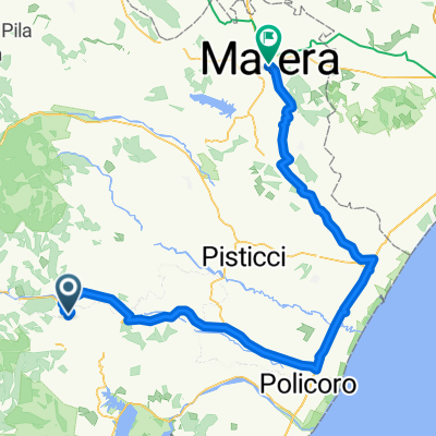
- Distance
- 2.1 km
- Ascent
- 560 m
- Descent
- 561 m
- Location
- Aliano, Basilicate, Italy
 5a tappa ALIANO - Craco - Miglionico - MATERA KM 103 disl mt 1380
- Distance
- 103.3 km
- Ascent
- 1,098 m
- Descent
- 1,234 m
- Location
- Aliano, Basilicate, Italy
 6° tappa Aliano - Craco - Scanzano Jonico - Matera
- Distance
- 116 km
- Ascent
- 549 m
- Descent
- 669 m
- Location
- Aliano, Basilicate, Italy
 Aliano. Sentiero 3 Don Trajella
- Distance
- 7.5 km
- Ascent
- 446 m
- Descent
- 443 m
- Location
- Aliano, Basilicate, Italy
 Aliano-Craco
- Distance
- 28.7 km
- Ascent
- 893 m
- Descent
- 1,104 m
- Location
- Aliano, Basilicate, Italy
 Strada Provinciale Aliano - Alianello 3a nach Via Garaguso 32, Calciano
- Distance
- 110.5 km
- Ascent
- 4,053 m
- Descent
- 4,159 m
- Location
- Aliano, Basilicate, Italy
 Basilicata Coast to Coast DAY3
- Distance
- 88.2 km
- Ascent
- 584 m
- Descent
- 1,107 m
- Location
- Aliano, Basilicate, Italy
 jesus
jesus- Distance
- 84.1 km
- Ascent
- 1,449 m
- Descent
- 1,450 m
- Location
- Aliano, Basilicate, Italy
Open it in the app