
kommot
RdGA 2022 - Tag 1 - Variante
A cycling route starting in Publier, Auvergne-Rhône-Alpes, France.
Overview
About this route
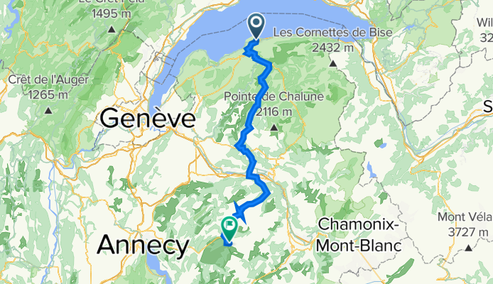
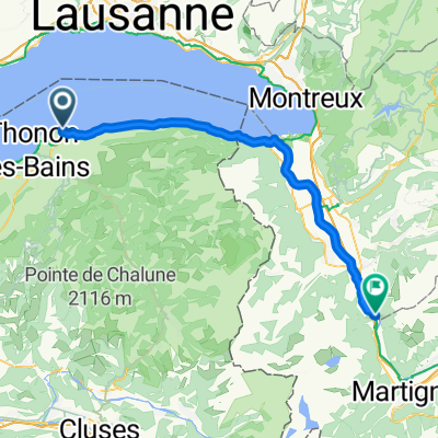
Thonon-les-Bains (Publier) to La Clusaz
Col de Jambaz (1027m), Col de la Colombière (1618m)
- -:--
- Duration
- 87.9 km
- Distance
- 2,524 m
- Ascent
- 1,842 m
- Descent
- ---
- Avg. speed
- 1,616 m
- Max. altitude

Part of
kommot
7 stages
Route quality
Waytypes & surfaces along the route
Waytypes
Quiet road
16.7 km
(19 %)
Road
7 km
(8 %)
Surfaces
Paved
60.6 km
(69 %)
Unpaved
1.8 km
(2 %)
Asphalt
59.8 km
(68 %)
Paved (undefined)
0.9 km
(1 %)
Continue with Bikemap
Use, edit, or download this cycling route
You would like to ride RdGA 2022 - Tag 1 - Variante or customize it for your own trip? Here is what you can do with this Bikemap route:
Free features
- Save this route as favorite or in collections
- Copy & plan your own version of this route
- Split it into stages to create a multi-day tour
- Sync your route with Garmin or Wahoo
Premium features
Free trial for 3 days, or one-time payment. More about Bikemap Premium.
- Navigate this route on iOS & Android
- Export a GPX / KML file of this route
- Create your custom printout (try it for free)
- Download this route for offline navigation
Discover more Premium features.
Get Bikemap PremiumFrom our community
Other popular routes starting in Publier
 Corsier
- Distance
- 76.8 km
- Ascent
- 640 m
- Descent
- 635 m
- Location
- Publier, Auvergne-Rhône-Alpes, France
 Lugrin
- Distance
- 37.7 km
- Ascent
- 501 m
- Descent
- 500 m
- Location
- Publier, Auvergne-Rhône-Alpes, France
 2 Park Dranse - Bois Noir
- Distance
- 57.7 km
- Ascent
- 245 m
- Descent
- 165 m
- Location
- Publier, Auvergne-Rhône-Alpes, France
 Allinges
- Distance
- 15.8 km
- Ascent
- 178 m
- Descent
- 176 m
- Location
- Publier, Auvergne-Rhône-Alpes, France
 Bons-en-Chablais kort
- Distance
- 52.7 km
- Ascent
- 564 m
- Descent
- 559 m
- Location
- Publier, Auvergne-Rhône-Alpes, France
 Dag 13 Rondrit Thonon-les-Bains
- Distance
- 66.1 km
- Ascent
- 1,264 m
- Descent
- 1,264 m
- Location
- Publier, Auvergne-Rhône-Alpes, France
 RdGA 2022 - Tag 1 - Variante
- Distance
- 87.9 km
- Ascent
- 2,524 m
- Descent
- 1,842 m
- Location
- Publier, Auvergne-Rhône-Alpes, France
 RdGA 2022 - Tag 1
- Distance
- 90.7 km
- Ascent
- 2,861 m
- Descent
- 2,165 m
- Location
- Publier, Auvergne-Rhône-Alpes, France
Open it in the app