Ros. Solvay-percorso del pellegrino-Livorno-Solvay
- 70.1 km
- 1,336 m
- 1,335 m
- Rosignano Solvay-Castiglioncello, Tuscany, Italy
A cycling route starting in Rosignano Solvay-Castiglioncello, Tuscany, Italy.
Overview
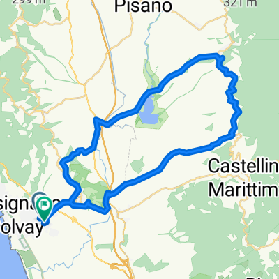
MTB route starting clockwise, then from Poggio Pelato counterclockwise, finally back at Poggio Pelato clockwise.
From Rosignano, you reach the "Spianate" and Poggio Pelato. Then continue to Nibbiaia and, via the Antica Via di Montenero (Viperaia), descend to Via della Valle del Chioma. Climb to the "Palazzine", where you take the left dirt road called "tagliafuoco". Follow it for about 4 km, then turn right to start the "percorso del pellegrino" loop: descend via del Puntone to Via di Sant'Alò, climb up to Monterrotondo and join the second part of the pilgrim's path leading to Pian della Rena. Reach Castellaccio and descend along the ridge road (the "voltine") down to Boccale. Reach Quercianella and, at the hamlet "Il Fortullino", climb back up to Poggio Pelato passing through San Quirico. Descend the "tagliola" to reach Rosignano Marittimo, cross the Poggetti park and return to Rosignano skirting the factory.
created this 3 years ago
Route quality
Track
36.3 km
(54 %)
Quiet road
8.8 km
(13 %)
Paved
17.5 km
(26 %)
Unpaved
32.3 km
(48 %)
Asphalt
15.5 km
(23 %)
Gravel
14.1 km
(21 %)
Continue with Bikemap
You would like to ride Ros. Solvay-Nibbiaia-percorso del pellegrino-Castellaccio-Solvay or customize it for your own trip? Here is what you can do with this Bikemap route:
Free trial for 3 days, or one-time payment. More about Bikemap Premium.
Discover more Premium features.
Get Bikemap PremiumFrom our community
Open it in the app