

Etapa 051B (Hartberg - Viena)
A cycling route starting in Hartberg, Styria, Austria.
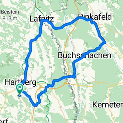
Overview
About this route
Vuelta a Europa occidental. Etapa 51
Hartberg - Penzendorf - Seibersdorf - Grafendorf bei Hartberg - Lafnitz - Rohrbachschlag - Limbach - Dechantskirchen - Stögersbach - Friedberg - Pinggau - Wiesenhöf - Schaueregg - Mönichkirchen - Aspang-Markt - Unteraspang - Olbersdorf - Lehensiedlung - Hütten - Petersbaumgarten - Warth - Scheiblingkirchen Thernberg - Gleißenfeld - Seebenstein - Sautern - Pitten - Bad Erlach - Lanzenkirchen - Kleinwolkersdorf - Frohsdorf - Katzelsdorf - Wiener Neustadt - Baden bei Wien - Traiskirchen - Guntramsdorf - Biedermannsdorf - Viena
158.2 km
1160 m desnivel positivo acumulado
- -:--
- Duration
- 158.2 km
- Distance
- 1,431 m
- Ascent
- 1,577 m
- Descent
- ---
- Avg. speed
- 954 m
- Max. altitude

Route quality
Waytypes & surfaces along the route
Waytypes
Quiet road
53.6 km
(34 %)
Cycleway
35.6 km
(22 %)
Surfaces
Paved
113.2 km
(72 %)
Unpaved
12.4 km
(8 %)
Asphalt
109.7 km
(69 %)
Gravel
8 km
(5 %)
Route highlights
Points of interest along the route
Point of interest after 81.3 km
Schloss Frohsdorf
Point of interest after 91.2 km
Wasserturm
Point of interest after 91.5 km
Theresianische Militärakademie
Point of interest after 91.8 km
Mariensäule
Point of interest after 91.9 km
Altes Rathaus
Point of interest after 92.2 km
Dom von Wiener Neustadt
Point of interest after 111.1 km
Kottingbrunn
Point of interest after 119.3 km
Baden Josefsplatz
Point of interest after 119.6 km
Beethoven-Haus
Point of interest after 120.1 km
Casino Baden
Point of interest after 120.6 km
Beethoventempel
Continue with Bikemap
Use, edit, or download this cycling route
You would like to ride Etapa 051B (Hartberg - Viena) or customize it for your own trip? Here is what you can do with this Bikemap route:
Free features
- Save this route as favorite or in collections
- Copy & plan your own version of this route
- Split it into stages to create a multi-day tour
- Sync your route with Garmin or Wahoo
Premium features
Free trial for 3 days, or one-time payment. More about Bikemap Premium.
- Navigate this route on iOS & Android
- Export a GPX / KML file of this route
- Create your custom printout (try it for free)
- Download this route for offline navigation
Discover more Premium features.
Get Bikemap PremiumFrom our community
Other popular routes starting in Hartberg
 Hartberg, Radmarathon 23. August 2015 - Strecke 64 km
- Distance
- 64.1 km
- Ascent
- 368 m
- Descent
- 373 m
- Location
- Hartberg, Styria, Austria
 Hartberg-Allhau-Stegersbach-Hartberg
- Distance
- 62.5 km
- Ascent
- 671 m
- Descent
- 701 m
- Location
- Hartberg, Styria, Austria
 Hartberg-Pöllauberg-Masenberg-Vorau-Hartberg Variante
- Distance
- 66.3 km
- Ascent
- 1,056 m
- Descent
- 1,057 m
- Location
- Hartberg, Styria, Austria
 HB-Allhau-Buchschachen-Pinkafeld-Lafnitz-HB
- Distance
- 50.5 km
- Ascent
- 546 m
- Descent
- 545 m
- Location
- Hartberg, Styria, Austria
 HB Stubenberg Kaindorf HB
- Distance
- 52.2 km
- Ascent
- 870 m
- Descent
- 870 m
- Location
- Hartberg, Styria, Austria
 Hartberg nach Varaždin
- Distance
- 167.7 km
- Ascent
- 1,562 m
- Descent
- 1,749 m
- Location
- Hartberg, Styria, Austria
 Hartberg-Grafendorf-Masenberg-Kaindorf-Sebersdorf-Neusafenau
- Distance
- 74.8 km
- Ascent
- 1,284 m
- Descent
- 1,290 m
- Location
- Hartberg, Styria, Austria
 Hartberg nach Varaždin
- Distance
- 161.9 km
- Ascent
- 1,497 m
- Descent
- 1,685 m
- Location
- Hartberg, Styria, Austria
Open it in the app