

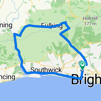
Hove Park to the South Downs
A cycling route starting in Hove, England, United Kingdom.
Overview
About this route
South downs loop. The cafe in Hove park is a good place to start. Good Coffee and cake.
- -:--
- Duration
- 49.7 km
- Distance
- 592 m
- Ascent
- 559 m
- Descent
- ---
- Avg. speed
- 230 m
- Max. altitude

Route quality
Waytypes & surfaces along the route
Waytypes
Busy road
16.8 km
(34 %)
Road
15.6 km
(31 %)
Surfaces
Paved
29.8 km
(60 %)
Unpaved
0.1 km
(<1 %)
Asphalt
18.6 km
(37 %)
Paved (undefined)
11.3 km
(23 %)
Continue with Bikemap
Use, edit, or download this cycling route
You would like to ride Hove Park to the South Downs or customize it for your own trip? Here is what you can do with this Bikemap route:
Free features
- Save this route as favorite or in collections
- Copy & plan your own version of this route
- Sync your route with Garmin or Wahoo
Premium features
Free trial for 3 days, or one-time payment. More about Bikemap Premium.
- Navigate this route on iOS & Android
- Export a GPX / KML file of this route
- Create your custom printout (try it for free)
- Download this route for offline navigation
Discover more Premium features.
Get Bikemap PremiumFrom our community
Other popular routes starting in Hove
 Hove Park to Bramber loop
- Distance
- 49.4 km
- Ascent
- 358 m
- Descent
- 381 m
- Location
- Hove, England, United Kingdom
 25m loop via Devils Dyke & Coombes
- Distance
- 40.8 km
- Ascent
- 272 m
- Descent
- 271 m
- Location
- Hove, England, United Kingdom
 lumpy loop
- Distance
- 41.3 km
- Ascent
- 314 m
- Descent
- 256 m
- Location
- Hove, England, United Kingdom
 Hove, Newhaven, Lewes, Hurstpierpoint, Henfield, Shoreham loop
- Distance
- 77.8 km
- Ascent
- 527 m
- Descent
- 554 m
- Location
- Hove, England, United Kingdom
 New training May/June
- Distance
- 14.7 km
- Ascent
- 37 m
- Descent
- 37 m
- Location
- Hove, England, United Kingdom
 15m Lunchtime loop
- Distance
- 24.7 km
- Ascent
- 212 m
- Descent
- 218 m
- Location
- Hove, England, United Kingdom
 Hove Park to the South Downs
- Distance
- 49.7 km
- Ascent
- 592 m
- Descent
- 559 m
- Location
- Hove, England, United Kingdom
 Hove - Devils Dyke short loop
- Distance
- 32.4 km
- Ascent
- 230 m
- Descent
- 228 m
- Location
- Hove, England, United Kingdom
Open it in the app