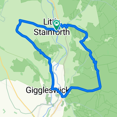
3 Peaks Route
- 113.9 km
- 940 m
- 940 m
- Settle, England, United Kingdom
A cycling route starting in Settle, England, United Kingdom.
Overview
created this 3 years ago
Route quality
Quiet road
25.1 km
(42 %)
Cycleway
11.9 km
(20 %)
Paved
35.8 km
(60 %)
Unpaved
2.4 km
(4 %)
Asphalt
35.8 km
(60 %)
Gravel
2.4 km
(4 %)
Undefined
21.5 km
(36 %)
Route highlights
Ring Cairn in Yorkshire (North) This ring cairn is scheduled as Historic England List ID 1013164, which tells us: "The ring cairn is situated on low ground between limestone outcrops. It is largely turf covered and includes a low, continuous ring bank approximately 0.5m high and 2m wide. The monument has a diameter of 19m. The centre has been disturbed at some time in the past and a 0.75m by 0.4m stone filled hole remains." It is also recorded as one of two monuments as part of "A group of Bronze Age barrows ... situated on the fell between Stackhouse and Feizor above Giggleswick Scar" - see Pastscape Monument No. 45639, the summary of which reads: "Earthwork remains of a Bronze Age ring cairn and site of a Bronze Age cairn. 19th century excavations uncovered human remains and an ivory disc." The Northern Antiquarian (TNA) also features a page on this site - see their entry for Sheep Scar Circle, Giggleswick, North Yorkshire, which gives directions for finding the site, together with photographs and a description from a recent visit and from Speight's 1892 publication.
Cave or Rock Shelter in Yorkshire (North) A cave high on the scree slope to the left of Victoria Cave. This cave has a gate across the front to try to help preserve the deposits still within it. It was excavated at the same time as Victoria Cave and the records on it are rather confused but it is known that a human burial was recorded as well as a flint scraper and Romano-British artefacts.
Possible Stone Circle or denuded cairn in Cumbria
Knipe Scar Tumuli submitted by MonumentMan Knipe Scar TumuliRound Cairn in Cumbria. A large Bronze Age Round Cairn found 150m East of Scarside Plantation on Knipe Scar common. A circular flat-topped turf covered mound of earth and stones, measuring 20m in diameter and up to 1.3m high, is surrounded by a ditch 2m wide and 0.1m deep. The top of the cairn has suffered shallow disturbance/excavation in three places and some component stones and boulders remain exposed forming hollows. About 120m to the northwest lies a smaller turf covered Round Cairn about 5.5m diameter by 0.5m high with a boulder on top (seen separately in photos).
Shap Avenue submitted by AngieLake Shap AvenueStone Avenue and Stone Rows linked to the stone circle in Cumbria. Shap Stone Row is a collection of standing stones and rocks forming an arc which starts just south of Shap Village at Kemp Howe Stone Circle. The row forms a rough southeast to northwest arc which runs for almost 2.5 kilometres, heading across the road from Kemp Howe, up through the village itself, then over the fields, ending just north of High Buildings Farm, north west of the village. As most of the stones are within sight of each other, it is easy to see how the stones fit the alignment, particularly from the higher points along the route, although it is very difficult to make out the two possible avenues the row forms. The stones are mainly of local, pink, granite. The Thunder Stone, and probably the Googleby Stone, are erratics, left by the glaciers, but forming major features of the stone row. See our Nearby Sites list below for links to the other sites. Whilst there are 14 stones now recorded by English Heritage, over the years the stones from the row have been reused, and part of the fun in exploring this ancient monument is coming across standing stones in gardens, within stone walls, and occasionally lying in the fields and next to footpaths. The focal point of the Stone Row is purported to be 2 stone circles at the south of Shap. The first is Kemp Howe, sadly now partly destroyed by blasting for the railway; a second, at Carl Loft, which I believe to lie behind the Greyhound Hotel at the south end of the village, has been mostly destroyed and lies on private
Iron Hill South submitted by stu Iron Hill SouthCairn-circle, with diameters 23 by 20 feet, Number of stones 9 There is no evidence that a relationship exists between this circle and the one to the N. The stones are quite prominent: the tallest is 4 feet. A low mound occupies the center, on top of which are 3 stones. For more information see Pastscape Monument No. 11894 which tells us this is: "A sub-oval hummocky mound up to 0.3m high with maximum dimensions of 6m by 5m. There is a partial ring of seven rounded pink granite boulders, formerly part of a kerb that surrounded the mound, with two more similar boulders lying beyond the partial ring a short distance to the south-east. Four boulders scattered on top of the mound are thought to be part of a cist. Limited antiquarian investigation at this site located the bones of a man, part of a deer antler and animal bones; scheduled."
Cave or Rock Shelter in Cumbria Cave used as a shelter in the Bronze age.
Kalmott cairn circle submitted by VapourTrail Kalmott cairn circleThis small ring cairn is situated right next to the Coast To Coast path leading from Oddendale village across to Seal Howe, within sight of the far larger, but less discernible ring cairn noted by Aubrey Burl ("A Guide to the Stone Circles...").
Threlkeld Knott Ancient Settlement in Cumbria
Great Mell Fell Tumulus is the site of a Bronze Age Round Cairn or Bowl Barrow on the landmark summit of Great Mell Fell (573m). A turf covered mound of stones 8.5-7m diameter and 0.8-0.4m high, which appears to have been previously excavated/disturbed. The site commands an excellent 360 degree panorama of the surrounding landscape. No doubt the purpose of its position was to command views/alignments to some of these existing natural features or other Bronze Age monuments, for the purpose of spiritual connection.
Newbeggin Stone Row Standing Stone (Menhir) in Cumbria The stone sits within a privately owned paddock in front of Sycamore View. Please seek permission before taking a closer look. The stone measures 800mm tall by 800mm wide by 800m deep, with the top seemingly shaped to form a triangle/pyramid to one side.
Dacre Church has Ancient Cross Shafts and Stones in St Andrew's Church, Dacre, Cumbria There are fragments from two cross shafts in the chancel which date from the 9th 10th centuries The smaller, which is believed to date from the 9th century, was found in 1900 close to the Church and deep in clay. It is considerably damaged but some detail of the carving is still quite sharp. The least damaged face of the shaft, where the top has been broken off, shows two pairs of human feet. Beneath is a lion-like winged creature, with a large face and sorrowful eyes, with the head and part of the body of a serpent. The larger stone was discovered amongst the rubble of the east wall may depict the ram sacrificed instead of Isaac. Immediately below is an antlered stag with a dog-like animal on its back. The "hart and hound" motif restoration work in 1875. It is believed to date from the 10th/11th century. At the top of the shaft are two human figures whose hands are joined over a retangular object with pellet-like legs. It is possible that the scene represents Abraham and Isaac. The strange looking four legged creature over their heads was often used, particularly by commentators of the bible such as the Venerable Bede, to symbolise the soul pursued by the forces of evil. The scene at the bottom of the shaft is thought to portray Adam and Eve in the Garden of Eden. Eve is reaching up to pick from the tree. She is wearing a skirt whilst Adam appears to be unclothed.
Castlesteads Earthwork in Cumbria If visiting St. Michael's Church at Lowther to see the Anglo Saxon fragments and cross, it is worth the 220m walk south to these earthworks perched high above the River Lowther. It is a very strategic spot and the earthworks measure 30 x 24 yards.
DunmallardHillfort in Cumbria Dunmallard hillfort sit at the end of Ullswater lake, guarding access to it, and to the mountain passes beyond. The people of this hillfort would effectively have control of the lake and the valley. Moor Divock cairns and Cockpit stone circle lie on the moorside to the south.
Low Moor Long Cairn in Cumbria lies alongside a road leading to Askham near to its junction with the A6. Measuring just over 100 metres, it's certainly long! Covered in trees, this cairn is best viewed in the winter.
Shapbeck Plantation Stone Circle in Cumbria. A very overgrown site where few of stones remain upright. Other stones in the circle look to have been disturbed and may not be in their original positions. An internal cairn looks to adjoin the circle's southern edge. The circle comprises the plough-damaged remains of 3 concentric rings of stones, surviving up to 0.90m above present ground level. The outer ring has 28 surviving stones and a diameter of c20-50m; 18 form the second and 7 the innermost. A small cairn, possibly added at a later date, overlies the second ring of stones at it's SW limit: no funerary evidence was found with it. Other small stones, particularly noticeable close to the NE edge of the outermost circle.
The Giant's Foot (Cumbria) Standing Stone in Cumbria This stone is a remainder of one of the stone avenues that once went through Shap The stone is also featured as part of the Stone Rows of Great Britain.
Castlehowe Scar Stone Row perhaps a Stone Row / Alignment in Cumbria It lies in the field adjacent to the Castlehowe Stone Circle, and shows evidence of a terminal cairn. It maybe an ancient track marker More information will be added as it becomes available, but in the meantime, all thoughts and comments are welcome.
Penhurrock remains of cairn, looks like Double Stone Row in Cumbria Sections of shap granite kerbstones can be seen on top of a mound/knoll, roughly describing a circle. Disturbed in the 19th Century. Now just scattered stones and a few large boulders. It was probably about 55' in diameter. (2) It is said that when the cairn was removed burnt bones were found in a small cist-like hole cut into the rock The 'few large boulders' comprise the SW and SE arcs of the peristalith."
Gamelands embanked stone circle. An oval enclosure of 40 large stones, all of which have fallen, and three smaller stones. All of the stones are Shap pink granite with the exception of one which is limestone. None exceed 0.9m in height and their circumferences at ground level vary between 1.9m and 3.8m. The stones are set into a slight bank approximately 2.5m wide and up to 0.2m high.
Little Asby Scar Round Cairn Bronze Age Round cairn, 450m NE of Mazon Wath farm. An oval mound of largely turf-covered limestone rubble up to 1.2m high with maximum dimensions of 13.3m by 11.5m. There is a central hollow c2m in diameter and 0.4m deep indicating unrecorded antiquarian excavation The Site commands a cliff top position just under Little Asby Scar, and overlooks Potts Valley Tarn. A prominent dry limestone ravine descends directly below the round cairn.
Crosby Ravensworth Stone Row circles in Cumbria
The rate at which you pay CGT following the sale of a buy-to-let property depends on your taxable income. If you’re a basic rate taxpayer with an income of £50,000 or less, the rate is 18%. Higher rate taxpayers with an income of £50,001 or more pay 28%.For example, if you bought a rental property ten years ago for £100,000 and sold it today for £150,000, your capital gain would be £50,000. Of this, £37,700 would be taxable (once your CGT allowance is deducted – see below). Assuming no other tax reliefs, your CGT bill on this transaction would be £6,786 (if you’re a basic-rate taxpayer) or £10,556 (if you’re a higher-rate taxpayer). The good news is that capital gains don’t count as income, so this £37,700 won’t push you into a higher tax bracket.
Marker Stone or Standing stone of unknown age. A 1.2m high and 0.2m deep narrow obelisk stone of Howgill Silurian Mudstone stands leaning at Black Moss and is found to be foreign on Limestone geology surrounded by shake holes. It is not thought to be a gate post, as no traces of wall or dyke surround it. The stone commands a moorland position underneath the slopes of Wild Boar Fell but is nearest to the road known as the Street which diverges to Uldale. Looking north the valley and Fell End Clouds Limestone escarpment is seen. Looking south the round profile of Bluecaster is visible.
Yordas Cave in Yorkshire (North) Previously a Victorian Showcave in which evidence of early human habitation was found. A wonderful place to spend an afternoon exploring with a torch. The highlight being the underground waterfall chamber at the back of the cave.
Castlerigg Stone Circle is of the best known and best preserved circles in Cumbria. A ring of 38 stones stands within a spectacular ring of mountains. Looking to the north you see Skiddaw and Blencathra, to the south High Rigg and Helvellyn, to the west the Derwent Fells and to the east through a gap, the Northern Pennines. Under the guardianship of the National Trust, Castlerigg is one of the UK’s earliest stone circles, dating to the Neolithic around 3000BC. Of the 38 stones, most of which are glacial erratics, 33 still stand, while a further 10 form a rectangular enclosure or sanctuary inside the ring, a feature unique to this site. Most of the stones are around 1m in height, but those closer to the entrances at the north and south are larger. The tallest stone is over 2m high, weighing around 15 tonnes. An outlying stone (not in its original position) is located 90m to the south-west close to a dry stone wall. One of the stones at the eastern side is said to be magnetic in nature, the whole site acting, perhaps, as a kind of power -point A number of leylines are said to pass through the circle.
Howes Well ring cairn circle of stones surrounding the possible stones of a cist, in a wonderful setting.
Apron Full of Stones This romantically named site is a large ring cairn of gritstone and sandstone boulders perched on the eastern edge of Kingsdale Beck. It was excavated in 1972 and a cremation burial was found with no grave goods. Two further possible grave pits proved to be empty. The structure of the cairn is simple and of a single period with a boulder kerb. The stones forming the body of the cairn are graded in size with the larger stones towards the base of the structure. The use of gritstone and sandstone is unusual since the site stands on limestone. Construction of the monument seems to represent clearance of glacial stone deposits scattered over a considerable area, perhaps as part of farming activity. A small collection of flints suggested an early Bronze Age date. The low-lying location has led at least one archaeologist to suggest that it is not a cairn at all, but a small henge. The revetment wall below the cairn was built by the National Park Authority to prevent further stream erosion.
Fell End Stone Circle Modern Stone Circle in Cumbria. A circle of 5 large (1-1.5m) limestone boulders are spaced regularly around a central limestone boulder (1.5-1.8m) The circle of stones is about 15m across but is raised on a platformed earth bank 20-25m across. The central boulder is again raised on a mound somewhat above the 5 surrounding stones. The source of the boulders is believed to be from the local area east of the site which has many large limestone boulders broken off the escarpment of Fell End Clouds below Wild Boar Fell.
Bent's Hill Round Cairn NW of the old Lime Kiln. Probable Neolithic round cairn with past excavation uncovering primary burials (Greenwell) of the disarticulated remains of 3 adults, 7 adolescents and 2 children. The cairn measures 11m in diameter and 1.2m high. Mainly turf covered with only a few limestone and sandstone slabs visible. The hilltop cairn overlooks unusual outcrops of sandstone geology, emerging from beneath the upper limestone, near Bents Farm. This cairn being one of two cairns on Crosby Garrett Fell
Ewe Moor Ring Cairn in Yorkshire This ring cairn is situated on the NW edge of Ewe Moor, overlooking Malham Cove. Most of the cairn is turf covered, but according to the NMR underneath lays a monument with 19 meter diameter; banks that stand 50cm in height.
CANAL ROUTE GARGRAVE TO SKIPTON 5 MILES
Nettlehole Ridge Circle in North Yorkshire. Only a few stones remain in this circle and they’re probably not in their original positions. The circle is situated on land owned by the Forestry Commission and it’s not easily accessible
The Northern Antiquarian sites the cup and ring stone - Low Snaygill Stone, Skipton, North Yorkshire. TNA give directions for finding the stone, Hedges describes the stone as a "“Large fairly smooth grit rock sloping down to stream at E and into ground and grass at W. Eleven cups, circle of nine very small cups at one end, groove from depression, one other groove and possible cup." "The monument includes a carved gritstone rock, 1.2m by 1.6m by 0.5m. It is situated at Snaygill, at the side of a track, in a grassy bank, opposite Garth House. It is 4.7m away from Garth House, and 1.2m along the housewall if measured from the south east corner of the house. An accurate National Grid Reference is SD 99399 49729. This is not the rock's original position, but it is not thought to have been moved far. The carving consists of around eleven cups, a circle of nine very small cups at the north end of the rock, and a groove running approximately north-south. Another groove on the rock is probably natural."
Hamblethorpe (Low Bradley) Standing Stones in Yorkshire (North) These two monoliths at the bottom of the hill below the giant cairns on Bradley Moor - very much similar in appearance to those at Castlerigg . They're in a field (permission required) on the west-wide of the country road (though not visible from road) between Low Bradley and Kildwick. The tallest of the two is 5ft 8in tall, with its companion being less than 4ft in height. In the same field beneath the stones is a curious earthwork. It's possible that these two monoliths were once part of some Iron Age walling, as three lines of such walls occur further up the slopes (though none of the stones in the other walls are anything like as tall as these); but once again, without adequate archaeological excavations, we can't say for certain.
Continue with Bikemap
You would like to ride New Way of the Rings Day 4 Settle to Ilkley or customize it for your own trip? Here is what you can do with this Bikemap route:
Free trial for 3 days, or one-time payment. More about Bikemap Premium.
Discover more Premium features.
Get Bikemap PremiumFrom our community
Open it in the app