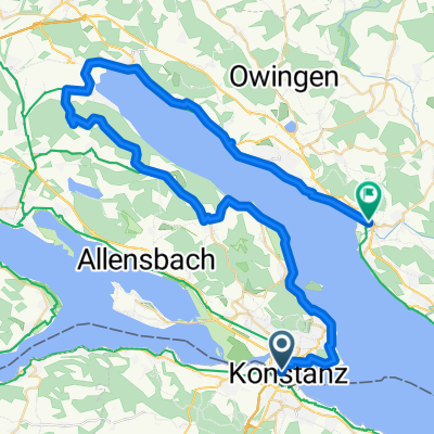
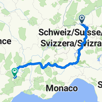
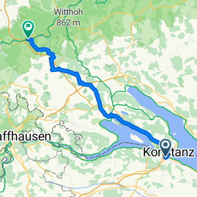
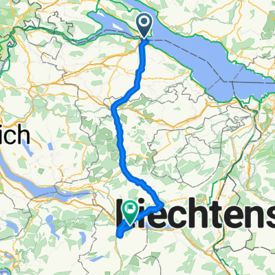
Bodensee-Radweg
A cycling route starting in Kreuzlingen, Thurgau, Switzerland.
Overview
About this route
- -:--
- Duration
- 260 km
- Distance
- 1,140 m
- Ascent
- 1,131 m
- Descent
- ---
- Avg. speed
- 556 m
- Avg. speed
Route quality
Waytypes & surfaces along the route
Waytypes
Quiet road
87.5 km
(34 %)
Path
57 km
(22 %)
Surfaces
Paved
229.1 km
(88 %)
Unpaved
21.3 km
(8 %)
Asphalt
222.5 km
(86 %)
Gravel
10.1 km
(4 %)
Continue with Bikemap
Use, edit, or download this cycling route
You would like to ride Bodensee-Radweg or customize it for your own trip? Here is what you can do with this Bikemap route:
Free features
- Save this route as favorite or in collections
- Copy & plan your own version of this route
- Split it into stages to create a multi-day tour
- Sync your route with Garmin or Wahoo
Premium features
Free trial for 3 days, or one-time payment. More about Bikemap Premium.
- Navigate this route on iOS & Android
- Export a GPX / KML file of this route
- Create your custom printout (try it for free)
- Download this route for offline navigation
Discover more Premium features.
Get Bikemap PremiumFrom our community
Other popular routes starting in Kreuzlingen
- Untersee
- Distance
- 70.5 km
- Ascent
- 218 m
- Descent
- 219 m
- Location
- Kreuzlingen, Thurgau, Switzerland
- Rund um den Ottoberg
- Distance
- 45.7 km
- Ascent
- 344 m
- Descent
- 341 m
- Location
- Kreuzlingen, Thurgau, Switzerland
- ETAPE 1 : Kreuzlingen / Uberlingen
- Distance
- 46 km
- Ascent
- 252 m
- Descent
- 258 m
- Location
- Kreuzlingen, Thurgau, Switzerland
- Samstagmittagrunde
- Distance
- 46.3 km
- Ascent
- 288 m
- Descent
- 291 m
- Location
- Kreuzlingen, Thurgau, Switzerland
- Bodenseeradweg ab Friedrichshafen
- Distance
- 255.9 km
- Ascent
- 268 m
- Descent
- 268 m
- Location
- Kreuzlingen, Thurgau, Switzerland
- Rundfahrt Kreuzlingen - Bättershausen - Bommerweiher - Steckborn - Kreuzlingen
- Distance
- 71.5 km
- Ascent
- 920 m
- Descent
- 920 m
- Location
- Kreuzlingen, Thurgau, Switzerland
- D 251 Konstanz - Stein am Rhein
- Distance
- 29.5 km
- Ascent
- 75 m
- Descent
- 75 m
- Location
- Kreuzlingen, Thurgau, Switzerland
- Wäldi-Runde
- Distance
- 21.4 km
- Ascent
- 237 m
- Descent
- 207 m
- Location
- Kreuzlingen, Thurgau, Switzerland
Open it in the app