
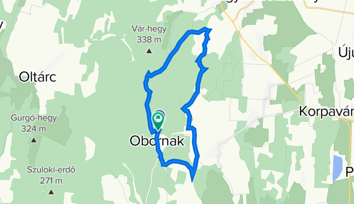
Obornak Várdomb kör
A cycling route starting in Nagykanizsa, Zala County, Hungary.
Overview
About this route
From Obornakról to Várhegy there is good quality asphalt, the other tourist paths and mountain roads need to be stabilized in sections 'B'.
- -:--
- Duration
- 14.7 km
- Distance
- 343 m
- Ascent
- 349 m
- Descent
- ---
- Avg. speed
- 304 m
- Max. altitude

Route quality
Waytypes & surfaces along the route
Waytypes
Track
13.5 km
(92 %)
Road
1 km
(7 %)
Quiet road
0.1 km
(1 %)
Surfaces
Paved
0.7 km
(5 %)
Unpaved
8.1 km
(55 %)
Ground
7.8 km
(53 %)
Paved (undefined)
0.6 km
(4 %)
Route highlights
Points of interest along the route
Point of interest after 2.4 km
Aszfaltút vége Obornak felől
Continue with Bikemap
Use, edit, or download this cycling route
You would like to ride Obornak Várdomb kör or customize it for your own trip? Here is what you can do with this Bikemap route:
Free features
- Save this route as favorite or in collections
- Copy & plan your own version of this route
- Sync your route with Garmin or Wahoo
Premium features
Free trial for 3 days, or one-time payment. More about Bikemap Premium.
- Navigate this route on iOS & Android
- Export a GPX / KML file of this route
- Create your custom printout (try it for free)
- Download this route for offline navigation
Discover more Premium features.
Get Bikemap PremiumFrom our community
Other popular routes starting in Nagykanizsa
 Murafölde kör 3
- Distance
- 219.8 km
- Ascent
- 2,889 m
- Descent
- 2,891 m
- Location
- Nagykanizsa, Zala County, Hungary
 Börzönce1
- Distance
- 65.4 km
- Ascent
- 327 m
- Descent
- 327 m
- Location
- Nagykanizsa, Zala County, Hungary
 Obornak_Várdomb
- Distance
- 3.7 km
- Ascent
- 136 m
- Descent
- 8 m
- Location
- Nagykanizsa, Zala County, Hungary
 Mórichelyi kör
- Distance
- 31 km
- Ascent
- 402 m
- Descent
- 402 m
- Location
- Nagykanizsa, Zala County, Hungary
 MURA_Kanizsa_50
- Distance
- 49.6 km
- Ascent
- 178 m
- Descent
- 178 m
- Location
- Nagykanizsa, Zala County, Hungary
 Várdomb_Homokkomárom_Palin
- Distance
- 18.9 km
- Ascent
- 319 m
- Descent
- 437 m
- Location
- Nagykanizsa, Zala County, Hungary
 Murafölde kör 1
- Distance
- 220.7 km
- Ascent
- 1,244 m
- Descent
- 1,244 m
- Location
- Nagykanizsa, Zala County, Hungary
 Tengerre magyar 1.st day
- Distance
- 174.9 km
- Ascent
- 410 m
- Descent
- 437 m
- Location
- Nagykanizsa, Zala County, Hungary
Open it in the app