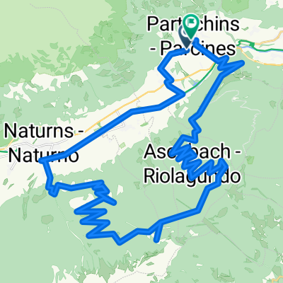
Von Algund ins Passeiertal
A cycling route starting in Partschins, Trentino-Alto Adige, Italy.
Overview
About this route
Diese wunderschöne Tour beginnt vom Hotel, fahren Sie bis zum Radweg, folgen Sie diesem nach Meran. Nachdem Sie den ersten Fluss (Passer) überquert haben, geht es sofort links der Straße entlang der Marlinger Straße zum Thermenplatz. Von hieraus geht es weiter durch den Elisabethpark, raus aus dem Stadtgebiet. Sie fahren durch Obstwiesen bei leichter Steigung durch das landschaftlich reizvolle Passeiertal, mit Blick auf die umliegende Bergwelt. Der Radweg endet bei St.Leonhard. (Denselben Weg zurück)
Â
- -:--
- Duration
- 28 km
- Distance
- 532 m
- Ascent
- 430 m
- Descent
- ---
- Avg. speed
- 698 m
- Avg. speed
Route quality
Waytypes & surfaces along the route
Waytypes
Track
14.1 km
(50 %)
Quiet road
4.5 km
(16 %)
Surfaces
Paved
14.1 km
(51 %)
Unpaved
12.7 km
(45 %)
Asphalt
13.2 km
(47 %)
Loose gravel
6.6 km
(24 %)
Continue with Bikemap
Use, edit, or download this cycling route
You would like to ride Von Algund ins Passeiertal or customize it for your own trip? Here is what you can do with this Bikemap route:
Free features
- Save this route as favorite or in collections
- Copy & plan your own version of this route
- Sync your route with Garmin or Wahoo
Premium features
Free trial for 3 days, or one-time payment. More about Bikemap Premium.
- Navigate this route on iOS & Android
- Export a GPX / KML file of this route
- Create your custom printout (try it for free)
- Download this route for offline navigation
Discover more Premium features.
Get Bikemap PremiumFrom our community
Other popular routes starting in Partschins
- Partschinser Abendrunde
- Distance
- 22.6 km
- Ascent
- 1,226 m
- Descent
- 1,230 m
- Location
- Partschins, Trentino-Alto Adige, Italy
- Töll Passeiertal Töll
- Distance
- 55.7 km
- Ascent
- 578 m
- Descent
- 578 m
- Location
- Partschins, Trentino-Alto Adige, Italy
- 20221019 Töll - Dorf Tirol - Kuens - Meran - Töll
- Distance
- 36.7 km
- Ascent
- 1,107 m
- Descent
- 1,113 m
- Location
- Partschins, Trentino-Alto Adige, Italy
- Parschins - Stifsler-Joch
- Distance
- 73.1 km
- Ascent
- 2,421 m
- Descent
- 316 m
- Location
- Partschins, Trentino-Alto Adige, Italy
- Partschins-Tabland - Nassereither Hütte
- Distance
- 21.9 km
- Ascent
- 1,103 m
- Descent
- 1,107 m
- Location
- Partschins, Trentino-Alto Adige, Italy
- Partschins - Muthöfe
- Distance
- 38.9 km
- Ascent
- 1,355 m
- Descent
- 1,347 m
- Location
- Partschins, Trentino-Alto Adige, Italy
- Töll Kalterer See
- Distance
- 52.5 km
- Ascent
- 412 m
- Descent
- 675 m
- Location
- Partschins, Trentino-Alto Adige, Italy
- 20221020 Töll - Wasserfall - Partschins - Naturns - Töll
- Distance
- 36.5 km
- Ascent
- 1,418 m
- Descent
- 1,417 m
- Location
- Partschins, Trentino-Alto Adige, Italy
Open it in the app