Route from 9634–9650 W Old Charles Rd, Nine Mile Falls
- 14.3 km
- 226 m
- 144 m
- Fairwood, Washington, United States
A cycling route starting in Fairwood, Washington, United States.
Overview
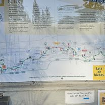
全長37英里(59公里)沿著
spokane river 走,37 miles 有停車場,3727起伏大,130 平緩好走,23~21是景觀旅館區,
created this 14 years ago
Route quality
Road
21.3 km
(36 %)
Quiet road
17.7 km
(30 %)
Paved
42 km
(71 %)
Asphalt
42 km
(71 %)
Undefined
17.2 km
(29 %)
Continue with Bikemap
You would like to ride Spokane river centennial trail or customize it for your own trip? Here is what you can do with this Bikemap route:
Free trial for 3 days, or one-time payment. More about Bikemap Premium.
Discover more Premium features.
Get Bikemap PremiumFrom our community
Open it in the app