

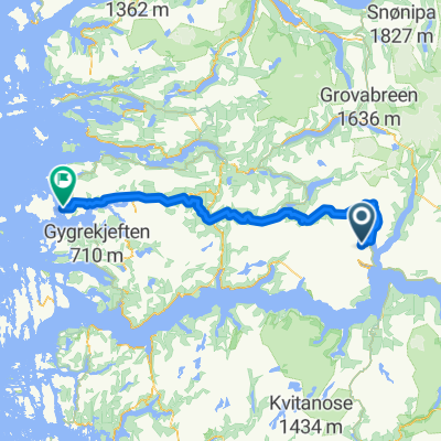
83. Dragsvik / Balestrand to Høyheimsvik
A cycling route starting in Balestrand, Sogn og Fjordane, Norway.
Overview
About this route
- -:--
- Duration
- 74.9 km
- Distance
- 2,093 m
- Ascent
- 2,061 m
- Descent
- ---
- Avg. speed
- 321 m
- Max. altitude

Route quality
Waytypes & surfaces along the route
Waytypes
Cycleway
39.7 km
(53 %)
Quiet road
5.2 km
(7 %)
Surfaces
Paved
65.2 km
(87 %)
Unpaved
3.7 km
(5 %)
Asphalt
65.2 km
(87 %)
Gravel
2.2 km
(3 %)
Route highlights
Points of interest along the route
Accommodation after 0 km
Kviknes Hotel
Point of interest after 0.1 km
Kræklingentunnelen Length: 337m Lighting: Yes Comments : I live here, and I've never been cycling through this tunnel due to the beautiful alternative route. Alternative route : There is a beautiful alternative at the narrow old road Villaveien.
Accommodation after 0.1 km
Midtnes Hotel
Point of interest after 0.1 km
St. Olaf's Church - The English Church
Accommodation after 0.1 km
Kringsjå Hotell
Accommodation after 0.1 km
Balestrand Hotel
Point of interest after 0.5 km
Ferry to Hella via Dragsvik 30 min M-F 0720 only
Accommodation after 1.9 km
Dragsvik Fjordhotel ? 2 night minimum
Accommodation after 2 km
Veganeset Camping cabins
Point of interest after 2.4 km
Dragsvik to Hella ferry 10 min 0605 0655 0740 0810 0900 0930 1000 1025 1100 then 1/2 hourly
Point of interest after 23.9 km
Bjørgahaug

Point of interest after 24.8 km
Fatlatunnelen Length: 2200m Lighting: Comments : Alternative route : Go via the old road around the tunnel on National Cycle route 6.

Point of interest after 35.7 km
Stedjebergtunnelen Length: 2100m Lighting: Yes Comments : Alternative route : Follow the National cycle route 6 signed cycle path that goes along the fjord shore.
Drinking water after 42.7 km
Dampskipskaien Cafe , Bar Restaurant
Point of interest after 49.4 km
Årøytunnelen Length: 430m Lighting: Yes Comments : It is possible but not fun. Little space. Alternative route : Use the small road east of 55.
Point of interest after 52.5 km
Stupshølentunnelen Length: 77m Lighting: None. Comments : Short easy tunnel.
Drinking water after 55.9 km
Lustraporten AS Restaurant
Point of interest after 57.3 km
Solvorn kyrkje
Drinking water after 57.3 km
Kvitabui Matnaust og Galleri Restaurant
Accommodation after 58.3 km
Hafslo Guesthouse
Accommodation after 59 km
BesteBakken
Point of interest after 64.1 km
Fet kyrkje
Drinking water after 64.8 km
Livdtun cafe
Point of interest after 67.3 km
Røneidtunnelen Length: 657m Lighting: Yes Comments : This tunnel is totally upgraded in 2018/2019. New lights, it even got these buttons on the outside where you can push to warn cars about cyclists the in tunnel. The old road by the fjord is also fully upgraded, with asphalt, and absolutely NO cars. Watch out for falling ice and rocks in the spring, it is not recommended to ride outside the tunnel from december to april. Alternative route : The old road by the fjord. Upgraded i 2017.
Point of interest after 70.9 km
Råumtunnelen Length: 514m Lighting: Yes Comments : This tunnel is fully upgraded in 2019. New and very good lightning. You can see through the entire tunnel. New signs, Syklist i tunnel, press the button and use them. Alternative route : The old road is in poor condition. It is rideable on MTB, gravel or CX. The scenery is nice though.
Point of interest after 74.9 km
Nes kyrkje
Accommodation after 74.9 km
Nes Gard
Continue with Bikemap
Use, edit, or download this cycling route
You would like to ride 83. Dragsvik / Balestrand to Høyheimsvik or customize it for your own trip? Here is what you can do with this Bikemap route:
Free features
- Save this route as favorite or in collections
- Copy & plan your own version of this route
- Sync your route with Garmin or Wahoo
Premium features
Free trial for 3 days, or one-time payment. More about Bikemap Premium.
- Navigate this route on iOS & Android
- Export a GPX / KML file of this route
- Create your custom printout (try it for free)
- Download this route for offline navigation
Discover more Premium features.
Get Bikemap PremiumFrom our community
Other popular routes starting in Balestrand
 Dragsvik 15 nach Sekundær Fylkesveg 451 22
- Distance
- 121.7 km
- Ascent
- 1,625 m
- Descent
- 1,414 m
- Location
- Balestrand, Sogn og Fjordane, Norway
 Day 1
Day 1- Distance
- 54.7 km
- Ascent
- 1,592 m
- Descent
- 1,183 m
- Location
- Balestrand, Sogn og Fjordane, Norway
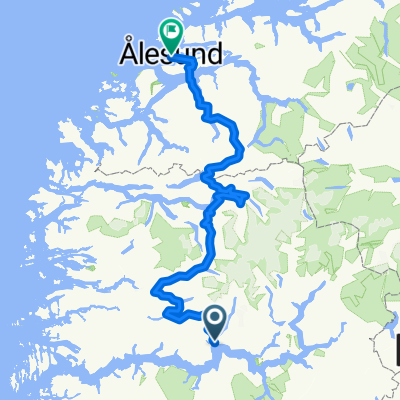 Sogndal - Ålesund
- Distance
- 319 km
- Ascent
- 4,311 m
- Descent
- 4,289 m
- Location
- Balestrand, Sogn og Fjordane, Norway
 83. Dragsvik / Balestrand to Høyheimsvik
- Distance
- 74.9 km
- Ascent
- 2,093 m
- Descent
- 2,061 m
- Location
- Balestrand, Sogn og Fjordane, Norway
 Balestrand - Hol
- Distance
- 233.6 km
- Ascent
- 4,756 m
- Descent
- 4,221 m
- Location
- Balestrand, Sogn og Fjordane, Norway
 Balestrand - Askvoll
- Distance
- 122.7 km
- Ascent
- 1,292 m
- Descent
- 1,470 m
- Location
- Balestrand, Sogn og Fjordane, Norway
 Noorwegen trip route 5: Balestrand - Lustrafjorden
- Distance
- 72.6 km
- Ascent
- 1,207 m
- Descent
- 1,244 m
- Location
- Balestrand, Sogn og Fjordane, Norway
 Balestrand - Kvamsøy
- Distance
- 12 km
- Ascent
- 130 m
- Descent
- 117 m
- Location
- Balestrand, Sogn og Fjordane, Norway
Open it in the app