

breathe
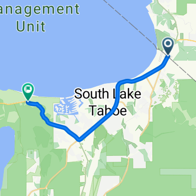
A cycling route starting in Kingsbury, Nevada, United States.
Overview
About this route
- -:--
- Duration
- 28.8 km
- Distance
- 534 m
- Ascent
- 674 m
- Descent
- ---
- Avg. speed
- 2,251 m
- Max. altitude
Route quality
Waytypes & surfaces along the route
Waytypes
Cycleway
7.5 km
(26 %)
Access road
1.7 km
(6 %)
Surfaces
Paved
27.1 km
(94 %)
Unpaved
0.3 km
(1 %)
Asphalt
27.1 km
(94 %)
Ground
0.3 km
(1 %)
Undefined
1.4 km
(5 %)
Continue with Bikemap
Use, edit, or download this cycling route
You would like to ride breathe or customize it for your own trip? Here is what you can do with this Bikemap route:
Free features
- Save this route as favorite or in collections
- Copy & plan your own version of this route
- Sync your route with Garmin or Wahoo
Premium features
Free trial for 3 days, or one-time payment. More about Bikemap Premium.
- Navigate this route on iOS & Android
- Export a GPX / KML file of this route
- Create your custom printout (try it for free)
- Download this route for offline navigation
Discover more Premium features.
Get Bikemap PremiumFrom our community
Other popular routes starting in Kingsbury
- breathe
- 28.8 km
- 534 m
- 674 m
- Kingsbury, Nevada, United States
- 15 US-50, Stateline to 1900 Jameson Beach Rd, South Lake Tahoe
- 12.2 km
- 98 m
- 110 m
- Kingsbury, Nevada, United States
- 1039 Fern Rd, South Lake Tahoe to 7035 N Lake Blvd, Tahoe Vista
- 51 km
- 937 m
- 954 m
- Kingsbury, Nevada, United States
- 1039 Fern Rd, South Lake Tahoe to US-50 E, Glenbrook
- 12.1 km
- 189 m
- 164 m
- Kingsbury, Nevada, United States
- Tahoe Rim Trail, Gardnerville to Quaking Aspen Lane 416, Stateline
- 10.3 km
- 1,003 m
- 1,145 m
- Kingsbury, Nevada, United States
- 98 Lake Village Dr, Round Hill to Squaw Ln, Round Hill
- 0.2 km
- 4 m
- 0 m
- Kingsbury, Nevada, United States
- tttt
- 86 km
- 1,418 m
- 1,392 m
- Kingsbury, Nevada, United States


Open it in the app