

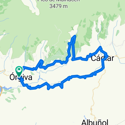
2-Órgiva-Uguíjar
A cycling route starting in Órgiva, Andalusia, Spain.
Overview
About this route
- -:--
- Duration
- 52.5 km
- Distance
- 1,374 m
- Ascent
- 1,269 m
- Descent
- ---
- Avg. speed
- 994 m
- Max. altitude

Route quality
Waytypes & surfaces along the route
Waytypes
Track
3.2 km
(6 %)
Road
2.6 km
(5 %)
Surfaces
Paved
46.8 km
(89 %)
Unpaved
0.5 km
(1 %)
Asphalt
45.2 km
(86 %)
Concrete
1.6 km
(3 %)
Continue with Bikemap
Use, edit, or download this cycling route
You would like to ride 2-Órgiva-Uguíjar or customize it for your own trip? Here is what you can do with this Bikemap route:
Free features
- Save this route as favorite or in collections
- Copy & plan your own version of this route
- Sync your route with Garmin or Wahoo
Premium features
Free trial for 3 days, or one-time payment. More about Bikemap Premium.
- Navigate this route on iOS & Android
- Export a GPX / KML file of this route
- Create your custom printout (try it for free)
- Download this route for offline navigation
Discover more Premium features.
Get Bikemap PremiumFrom our community
Other popular routes starting in Órgiva
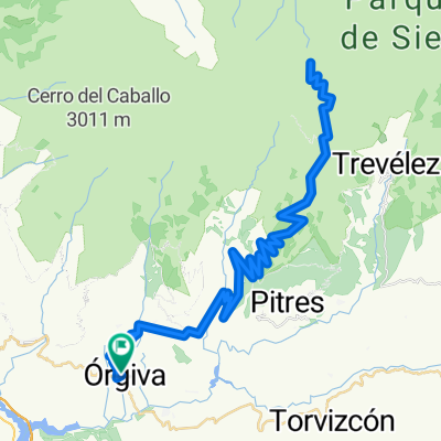
 Orgiva-Trevelez-Orgiva
- Distance
- 75.7 km
- Ascent
- 1,471 m
- Descent
- 1,471 m
- Location
- Órgiva, Andalusia, Spain
 SALIDA ALPUJARREÑA
- Distance
- 98.8 km
- Ascent
- 1,589 m
- Descent
- 1,588 m
- Location
- Órgiva, Andalusia, Spain
 Orgiva - Lanjaron - Durcal - Guajar Faragüit
- Distance
- 91.8 km
- Ascent
- 1,515 m
- Descent
- 1,512 m
- Location
- Órgiva, Andalusia, Spain
 AndenLucia 5 Órgiva Granada
- Distance
- 57.4 km
- Ascent
- 719 m
- Descent
- 490 m
- Location
- Órgiva, Andalusia, Spain
 Clásica de las Alpujarras
- Distance
- 187.2 km
- Ascent
- 3,592 m
- Descent
- 3,023 m
- Location
- Órgiva, Andalusia, Spain
 Orgiva - Mulhacen - Orgiva
- Distance
- 93.1 km
- Ascent
- 2,977 m
- Descent
- 2,977 m
- Location
- Órgiva, Andalusia, Spain
 Dag 2 - Orgiva - Trevelez -Pampaneira - Orgiva
- Distance
- 68.9 km
- Ascent
- 1,392 m
- Descent
- 1,392 m
- Location
- Órgiva, Andalusia, Spain
 S6: Picena von West
- Distance
- 138.3 km
- Ascent
- 4,156 m
- Descent
- 4,137 m
- Location
- Órgiva, Andalusia, Spain
Open it in the app