

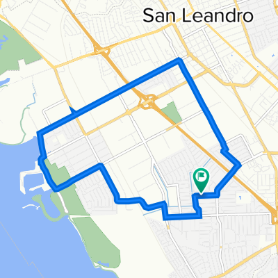
Cull Canyon, from San Leandro
A cycling route starting in San Lorenzo, California, United States of America.
Overview
About this route
Rather than a simple "Out & Back" this route adds a little variation to the trip by cruising through San Lorenzo, Cherryland, Castro Valley and Ashland. Cull Canyon itself is a scenic ride with gradual climbing and very little traffic if any as it is a dead end road. The only cars are usually local residents and they are accustomed to us bikers being there.
- -:--
- Duration
- 47.7 km
- Distance
- 546 m
- Ascent
- 546 m
- Descent
- ---
- Avg. speed
- 255 m
- Max. altitude

Route quality
Waytypes & surfaces along the route
Waytypes
Road
32.3 km
(68 %)
Busy road
13.4 km
(28 %)
Surfaces
Paved
6.8 km
(14 %)
Asphalt
5.3 km
(11 %)
Paved (undefined)
1.2 km
(2 %)
Continue with Bikemap
Use, edit, or download this cycling route
You would like to ride Cull Canyon, from San Leandro or customize it for your own trip? Here is what you can do with this Bikemap route:
Free features
- Save this route as favorite or in collections
- Copy & plan your own version of this route
- Sync your route with Garmin or Wahoo
Premium features
Free trial for 3 days, or one-time payment. More about Bikemap Premium.
- Navigate this route on iOS & Android
- Export a GPX / KML file of this route
- Create your custom printout (try it for free)
- Download this route for offline navigation
Discover more Premium features.
Get Bikemap PremiumFrom our community
Other popular routes starting in San Lorenzo
 Cull Canyon, from San Leandro
- Distance
- 47.7 km
- Ascent
- 546 m
- Descent
- 546 m
- Location
- San Lorenzo, California, United States of America
 Cumberland Avenue 1343, San Leandro to Cumberland Avenue 1343, San Leandro
- Distance
- 18.5 km
- Ascent
- 4 m
- Descent
- 6 m
- Location
- San Lorenzo, California, United States of America
 Hwy 92 to Coyote Hills/Alameda Creek
- Distance
- 13.5 km
- Ascent
- 0 m
- Descent
- 0 m
- Location
- San Lorenzo, California, United States of America
 San Lorenzo to Alameda - Crown Beach
- Distance
- 44.3 km
- Ascent
- 3 m
- Descent
- 12 m
- Location
- San Lorenzo, California, United States of America
 Recovered Route
- Distance
- 16.1 km
- Ascent
- 6 m
- Descent
- 3 m
- Location
- San Lorenzo, California, United States of America
 W Winton Ave, Hayward a Amador St, Hayward
- Distance
- 26.2 km
- Ascent
- 79 m
- Descent
- 67 m
- Location
- San Lorenzo, California, United States of America
 Marina loop
- Distance
- 11.7 km
- Ascent
- 24 m
- Descent
- 24 m
- Location
- San Lorenzo, California, United States of America
 Route from 3601–3609 Depot Rd, Hayward
- Distance
- 22 km
- Ascent
- 0 m
- Descent
- 3 m
- Location
- San Lorenzo, California, United States of America
Open it in the app