

Old Jacksonville Highway 6751, Tyler to Park Ridge Drive 2550, Tyler
A cycling route starting in Tyler, Texas, United States.
Overview
About this route
- 2 h 54 min
- Duration
- 21.3 km
- Distance
- 134 m
- Ascent
- 123 m
- Descent
- 7.3 km/h
- Avg. speed
- 178 m
- Max. altitude

Route photos


Route quality
Waytypes & surfaces along the route
Waytypes
Road
9.6 km
(45 %)
Quiet road
5.3 km
(25 %)
Surfaces
Paved
13.6 km
(64 %)
Asphalt
13 km
(61 %)
Concrete
0.6 km
(3 %)
Undefined
7.7 km
(36 %)
Continue with Bikemap
Use, edit, or download this cycling route
You would like to ride Old Jacksonville Highway 6751, Tyler to Park Ridge Drive 2550, Tyler or customize it for your own trip? Here is what you can do with this Bikemap route:
Free features
- Save this route as favorite or in collections
- Copy & plan your own version of this route
- Sync your route with Garmin or Wahoo
Premium features
Free trial for 3 days, or one-time payment. More about Bikemap Premium.
- Navigate this route on iOS & Android
- Export a GPX / KML file of this route
- Create your custom printout (try it for free)
- Download this route for offline navigation
Discover more Premium features.
Get Bikemap PremiumFrom our community
Other popular routes starting in Tyler
 Campus Dr, Tyler to 3121 Seaton St, Tyler
- Distance
- 8.9 km
- Ascent
- 64 m
- Descent
- 75 m
- Location
- Tyler, Texas, United States
 Old Jacksonville Highway 6751, Tyler to Park Ridge Drive 2550, Tyler
- Distance
- 21.3 km
- Ascent
- 134 m
- Descent
- 123 m
- Location
- Tyler, Texas, United States
 ride #1
- Distance
- 9.1 km
- Ascent
- 68 m
- Descent
- 67 m
- Location
- Tyler, Texas, United States
 Beginning Route
- Distance
- 9.2 km
- Ascent
- 49 m
- Descent
- 49 m
- Location
- Tyler, Texas, United States
 Brief bike tour through Tyler
- Distance
- 9.9 km
- Ascent
- 56 m
- Descent
- 70 m
- Location
- Tyler, Texas, United States
 saturday morning
- Distance
- 57.9 km
- Ascent
- 320 m
- Descent
- 320 m
- Location
- Tyler, Texas, United States
 Tyler to Kilgore
- Distance
- 54 km
- Ascent
- 514 m
- Descent
- 556 m
- Location
- Tyler, Texas, United States
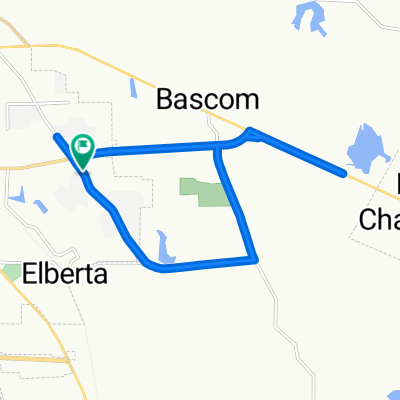 Old Omen Rd to Bascom Rd to Chapel Hill and back
- Distance
- 16 km
- Ascent
- 147 m
- Descent
- 147 m
- Location
- Tyler, Texas, United States
Open it in the app