
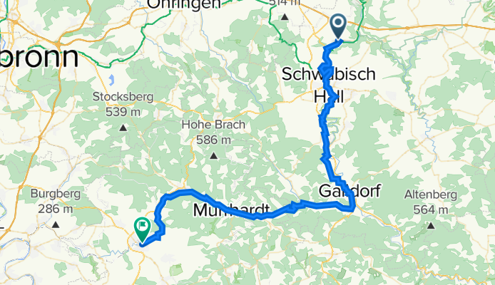
2022 Tag 2 Enslingen - Backnang
A cycling route starting in Untermünkheim, Baden-Wurttemberg, Germany.
Overview
About this route
- -:--
- Duration
- 64.1 km
- Distance
- 525 m
- Ascent
- 538 m
- Descent
- ---
- Avg. speed
- 430 m
- Max. altitude
Route quality
Waytypes & surfaces along the route
Waytypes
Quiet road
20.8 km
(32 %)
Track
15.2 km
(24 %)
Surfaces
Paved
53.2 km
(83 %)
Unpaved
4 km
(6 %)
Asphalt
48.4 km
(76 %)
Paved (undefined)
3.2 km
(5 %)
Continue with Bikemap
Use, edit, or download this cycling route
You would like to ride 2022 Tag 2 Enslingen - Backnang or customize it for your own trip? Here is what you can do with this Bikemap route:
Free features
- Save this route as favorite or in collections
- Copy & plan your own version of this route
- Sync your route with Garmin or Wahoo
Premium features
Free trial for 3 days, or one-time payment. More about Bikemap Premium.
- Navigate this route on iOS & Android
- Export a GPX / KML file of this route
- Create your custom printout (try it for free)
- Download this route for offline navigation
Discover more Premium features.
Get Bikemap PremiumFrom our community
Other popular routes starting in Untermünkheim
 Michelfeld
- Distance
- 19.9 km
- Ascent
- 175 m
- Descent
- 139 m
- Location
- Untermünkheim, Baden-Wurttemberg, Germany
 Schwäbisch Hall - Langenburg - Waldenburg - S.H.
- Distance
- 109.4 km
- Ascent
- 967 m
- Descent
- 968 m
- Location
- Untermünkheim, Baden-Wurttemberg, Germany
 zum Lemberghaus und weiter nach Gnadental
- Distance
- 15.6 km
- Ascent
- 344 m
- Descent
- 227 m
- Location
- Untermünkheim, Baden-Wurttemberg, Germany
 Wackershofen Bhf - SHA - Kochertalradweg - KÜN - Ohrnberg - Öhringen
- Distance
- 71.8 km
- Ascent
- 150 m
- Descent
- 264 m
- Location
- Untermünkheim, Baden-Wurttemberg, Germany
 Bühlerbachrunde bei Schwäbisch Hall
- Distance
- 38.3 km
- Ascent
- 458 m
- Descent
- 456 m
- Location
- Untermünkheim, Baden-Wurttemberg, Germany
 OMH - Starkh.b. - Bubeno. - Mittelsteinach - Neumühlsee - OMH
- Distance
- 44.4 km
- Ascent
- 608 m
- Descent
- 609 m
- Location
- Untermünkheim, Baden-Wurttemberg, Germany
 Kochertal Aalen - Schwäbisch Hall - Bad Friedrichsau Tag 2
- Distance
- 73.8 km
- Ascent
- 683 m
- Descent
- 784 m
- Location
- Untermünkheim, Baden-Wurttemberg, Germany
 Obermünkheim - Waldenburg - Frohnfalls - Rottal
- Distance
- 60 km
- Ascent
- 573 m
- Descent
- 573 m
- Location
- Untermünkheim, Baden-Wurttemberg, Germany
Open it in the app