Percorso da Via Bruno Buozzi
- 34.2 km
- 532 m
- 574 m
- Rosignano Solvay-Castiglioncello, Tuscany, Italy
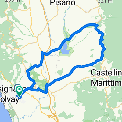
A cycling route starting in Rosignano Solvay-Castiglioncello, Tuscany, Italy.
Overview
MTB route counterclockwise, with the Sambuca loop clockwise.
You reach Fortullino and ascend on dirt to San Quirico and Pian dei Lupi, then reach the SP that climbs from Castelnuovo. We head towards Nibbiaia and before the village, on a big bend, we take the dirt road to the right, Via Buontalenti. We reach the provincial road, turn right for a few meters, then take the dirt road on the left, Poggio d'Arco. We arrive at Piccionaia and on asphalt go towards Livorno and at the "Specchi" we take the dirt road on the right that leads us to Valle Benedetta. We enter the Forest of Valle Benedetta and at the fork to the Eremo we go left to complete the loop that includes Sambuca. We return to Valle Benedetta for a lunch stop at the trattoria Camporeggi. We go back to Crocifisso and take Via della Sambuca. The road soon becomes dirt (with a trail section) and takes us to the Acquedotto Leopoldino. We return to Via della Valle Benedetta, reach the Palazzine, and take the firebreak. At the fork at Pian della Rena we take right and emerge on Via della Porcigliana. We reach Montenero Alto, climb Via del Poggio and reach Castellaccio. We descend to the curve and Nuovolari and, just after the Tavola Calda "Da Rosa", we enter the dirt road on the left (attention!!! ... there is a chain). The trail "la sgambata" (after which you enjoy one of the most beautiful views of the coast), Via degli Albatri, and other little streets lead us to Quercianella on Via Aurelia. We take left and return to Rosignano Solvay.
created this 3 years ago
Route quality
Track
25.5 km
(39 %)
Quiet road
9.1 km
(14 %)
Paved
24.2 km
(37 %)
Unpaved
28.1 km
(43 %)
Asphalt
24.2 km
(37 %)
Gravel
10.4 km
(16 %)
Continue with Bikemap
You would like to ride Ros. Solvay-anello Sambuca-Montenero-Solvay or customize it for your own trip? Here is what you can do with this Bikemap route:
Free trial for 3 days, or one-time payment. More about Bikemap Premium.
Discover more Premium features.
Get Bikemap PremiumFrom our community
Open it in the app