

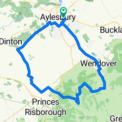
Route from 2 Thackeray End, Aylesbury
A cycling route starting in Aylesbury, England, United Kingdom.
Overview
About this route
- 40 min
- Duration
- 9.1 km
- Distance
- 62 m
- Ascent
- 64 m
- Descent
- 13.7 km/h
- Avg. speed
- 101 m
- Max. altitude
Route quality
Waytypes & surfaces along the route
Waytypes
Cycleway
6 km
(66 %)
Quiet road
1.2 km
(13 %)
Surfaces
Paved
7 km
(77 %)
Paved (undefined)
4.9 km
(54 %)
Asphalt
2.1 km
(23 %)
Undefined
2.1 km
(23 %)
Continue with Bikemap
Use, edit, or download this cycling route
You would like to ride Route from 2 Thackeray End, Aylesbury or customize it for your own trip? Here is what you can do with this Bikemap route:
Free features
- Save this route as favorite or in collections
- Copy & plan your own version of this route
- Sync your route with Garmin or Wahoo
Premium features
Free trial for 3 days, or one-time payment. More about Bikemap Premium.
- Navigate this route on iOS & Android
- Export a GPX / KML file of this route
- Create your custom printout (try it for free)
- Download this route for offline navigation
Discover more Premium features.
Get Bikemap PremiumFrom our community
Other popular routes starting in Aylesbury
 Aylesbury Quick Training Route
- Distance
- 20 km
- Ascent
- 58 m
- Descent
- 56 m
- Location
- Aylesbury, England, United Kingdom
 Easy ride in Aylesbury
- Distance
- 13.3 km
- Ascent
- 29 m
- Descent
- 32 m
- Location
- Aylesbury, England, United Kingdom
 Station Way W, Aylesbury to College Lake Wildlife Centre, Upper Icknield Way, Tring
- Distance
- 14.3 km
- Ascent
- 334 m
- Descent
- 281 m
- Location
- Aylesbury, England, United Kingdom
 trial ride
- Distance
- 36.7 km
- Ascent
- 250 m
- Descent
- 250 m
- Location
- Aylesbury, England, United Kingdom
 48 MILE AYLESBURY
- Distance
- 78.5 km
- Ascent
- 361 m
- Descent
- 359 m
- Location
- Aylesbury, England, United Kingdom
 Waddesdon
- Distance
- 13 km
- Ascent
- 142 m
- Descent
- 114 m
- Location
- Aylesbury, England, United Kingdom
 Watermead, Winslow, Horwood, Mursley cafe, Stewkley and back
- Distance
- 54.3 km
- Ascent
- 434 m
- Descent
- 484 m
- Location
- Aylesbury, England, United Kingdom
 Moderate route in Aylesbury
- Distance
- 5.6 km
- Ascent
- 32 m
- Descent
- 33 m
- Location
- Aylesbury, England, United Kingdom
Open it in the app