

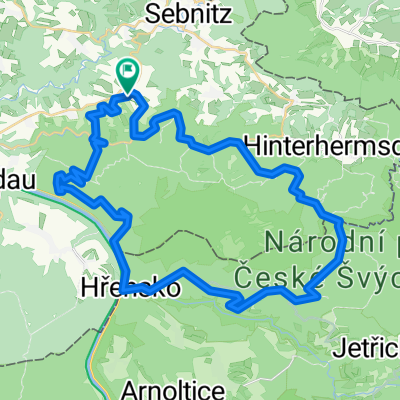
Hinterhermsdorf-Panoramaweg-Bad Schandau-Nationalpark
A cycling route starting in Sebnitz, Saxony, Germany.
Overview
About this route
sehr zu empfehlen in der tollen Natur! sehr abwechslungsreich, da Wechsel der Umgebung, der Oberflächen, Steigung und Abfahrt...Sehr schön!!!
- -:--
- Duration
- 46.1 km
- Distance
- 693 m
- Ascent
- 693 m
- Descent
- ---
- Avg. speed
- ---
- Max. altitude
Continue with Bikemap
Use, edit, or download this cycling route
You would like to ride Hinterhermsdorf-Panoramaweg-Bad Schandau-Nationalpark or customize it for your own trip? Here is what you can do with this Bikemap route:
Free features
- Save this route as favorite or in collections
- Copy & plan your own version of this route
- Sync your route with Garmin or Wahoo
Premium features
Free trial for 3 days, or one-time payment. More about Bikemap Premium.
- Navigate this route on iOS & Android
- Export a GPX / KML file of this route
- Create your custom printout (try it for free)
- Download this route for offline navigation
Discover more Premium features.
Get Bikemap PremiumFrom our community
Other popular routes starting in Sebnitz
 Hinterhermsdorf-Panoramaweg-Bad Schandau-Nationalpark
- Distance
- 46.1 km
- Ascent
- 693 m
- Descent
- 693 m
- Location
- Sebnitz, Saxony, Germany
 Panoramatour Sächsische Schweiz
- Distance
- 56.3 km
- Ascent
- 581 m
- Descent
- 581 m
- Location
- Sebnitz, Saxony, Germany
 Sächsische-Böhmische-Schweiz - Runde
- Distance
- 42.5 km
- Ascent
- 394 m
- Descent
- 394 m
- Location
- Sebnitz, Saxony, Germany
 Hinterhermsdorf - Ruppersdorf
- Distance
- 65.6 km
- Ascent
- 571 m
- Descent
- 618 m
- Location
- Sebnitz, Saxony, Germany
 Hinterhermsdorf Runde (Czech)
- Distance
- 42.2 km
- Ascent
- 594 m
- Descent
- 594 m
- Location
- Sebnitz, Saxony, Germany
 Sebnitz - Kyjov - Sebnitz
- Distance
- 43.9 km
- Ascent
- 608 m
- Descent
- 608 m
- Location
- Sebnitz, Saxony, Germany
 Zwischen Kirnitzschtal und Balzhütten
- Distance
- 38 km
- Ascent
- 415 m
- Descent
- 415 m
- Location
- Sebnitz, Saxony, Germany
 Kleines Prebischtor, Var. 2
- Distance
- 46.8 km
- Ascent
- 586 m
- Descent
- 586 m
- Location
- Sebnitz, Saxony, Germany
Open it in the app