

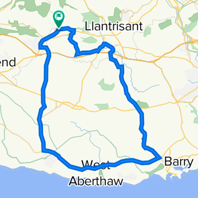
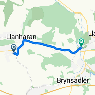
Granny's To Mum's
A cycling route starting in Llanharan, Wales, United Kingdom.
Overview
About this route
- -:--
- Duration
- 12.6 km
- Distance
- 231 m
- Ascent
- 147 m
- Descent
- ---
- Avg. speed
- 226 m
- Max. altitude
Route quality
Waytypes & surfaces along the route
Waytypes
Quiet road
4.6 km
(36 %)
Busy road
3.7 km
(30 %)
Surfaces
Paved
8.4 km
(67 %)
Asphalt
8.4 km
(67 %)
Undefined
4.1 km
(33 %)
Route highlights
Points of interest along the route
Point of interest after 1.2 km
Point of interest after 1.5 km
Point of interest after 1.6 km
Point of interest after 1.8 km
Point of interest after 2.2 km
Point of interest after 2.3 km
Point of interest after 2.9 km
Point of interest after 3.5 km
Point of interest after 3.8 km
Point of interest after 5.1 km
Point of interest after 5.3 km
Point of interest after 5.6 km
Point of interest after 6 km
Point of interest after 6.1 km
Point of interest after 6.2 km
Point of interest after 6.7 km
Point of interest after 7 km
Point of interest after 7.1 km
Point of interest after 7.6 km
Point of interest after 9 km
Point of interest after 9.2 km
Point of interest after 12.2 km
Point of interest after 12.3 km
Continue with Bikemap
Use, edit, or download this cycling route
You would like to ride Granny's To Mum's or customize it for your own trip? Here is what you can do with this Bikemap route:
Free features
- Save this route as favorite or in collections
- Copy & plan your own version of this route
- Sync your route with Garmin or Wahoo
Premium features
Free trial for 3 days, or one-time payment. More about Bikemap Premium.
- Navigate this route on iOS & Android
- Export a GPX / KML file of this route
- Create your custom printout (try it for free)
- Download this route for offline navigation
Discover more Premium features.
Get Bikemap PremiumFrom our community
Other popular routes starting in Llanharan
 29 Southall St, Pontyclun to 29 Southall St, Pontyclun
- Distance
- 30 km
- Ascent
- 259 m
- Descent
- 256 m
- Location
- Llanharan, Wales, United Kingdom
 6 Church St, Pontyclun to 10 Church St, Pontyclun
- Distance
- 55.8 km
- Ascent
- 560 m
- Descent
- 569 m
- Location
- Llanharan, Wales, United Kingdom
 Brynna woods - Llanharry
- Distance
- 14.9 km
- Ascent
- 166 m
- Descent
- 164 m
- Location
- Llanharan, Wales, United Kingdom
 Llanharan Community, Pontyclun to Llanharan Community, Pontyclun
- Distance
- 17.3 km
- Ascent
- 306 m
- Descent
- 333 m
- Location
- Llanharan, Wales, United Kingdom
 29 Southall St, Pontyclun to 29 Southall St, Pontyclun
- Distance
- 29.8 km
- Ascent
- 253 m
- Descent
- 250 m
- Location
- Llanharan, Wales, United Kingdom
 29 Southall St, Pontyclun to 6 Church View, Pontyclun
- Distance
- 29.9 km
- Ascent
- 249 m
- Descent
- 246 m
- Location
- Llanharan, Wales, United Kingdom
 29 Southall St, Pontyclun to 12 Llanbad, Pontyclun
- Distance
- 29.5 km
- Ascent
- 242 m
- Descent
- 240 m
- Location
- Llanharan, Wales, United Kingdom
 41 Parc Bryn Derwen, Pontyclun to 24 Lanelay Close, Pontyclun
- Distance
- 5 km
- Ascent
- 27 m
- Descent
- 59 m
- Location
- Llanharan, Wales, United Kingdom
Open it in the app