

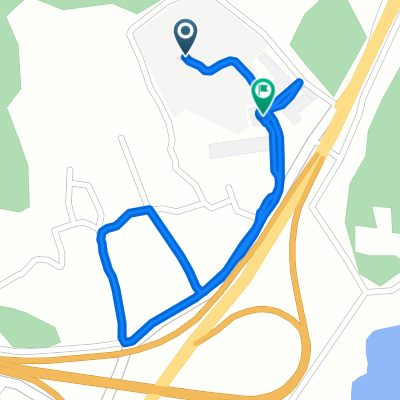
산양읍 72−3, 통영시 to 도남동 645, 통영시
A cycling route starting in Kyosai, Gyeongsangnam-do, South Korea.
Overview
About this route
- 55 min
- Duration
- 6.6 km
- Distance
- 20 m
- Ascent
- 28 m
- Descent
- 7.3 km/h
- Avg. speed
- 57 m
- Max. altitude

Route photos


Route quality
Waytypes & surfaces along the route
Waytypes
Cycleway
4.9 km
(74 %)
Quiet road
1.7 km
(26 %)
Continue with Bikemap
Use, edit, or download this cycling route
You would like to ride 산양읍 72−3, 통영시 to 도남동 645, 통영시 or customize it for your own trip? Here is what you can do with this Bikemap route:
Free features
- Save this route as favorite or in collections
- Copy & plan your own version of this route
- Sync your route with Garmin or Wahoo
Premium features
Free trial for 3 days, or one-time payment. More about Bikemap Premium.
- Navigate this route on iOS & Android
- Export a GPX / KML file of this route
- Create your custom printout (try it for free)
- Download this route for offline navigation
Discover more Premium features.
Get Bikemap PremiumFrom our community
Other popular routes starting in Kyosai
 통영 bike
- Distance
- 43.8 km
- Ascent
- 642 m
- Descent
- 635 m
- Location
- Kyosai, Gyeongsangnam-do, South Korea
 산양읍 72−3, 통영시 to 도남동 645, 통영시
- Distance
- 6.6 km
- Ascent
- 20 m
- Descent
- 28 m
- Location
- Kyosai, Gyeongsangnam-do, South Korea
 part3 Tongyung-si Busan
- Distance
- 134.8 km
- Ascent
- 816 m
- Descent
- 807 m
- Location
- Kyosai, Gyeongsangnam-do, South Korea
 한산도 라이딩
- Distance
- 38.2 km
- Ascent
- 862 m
- Descent
- 862 m
- Location
- Kyosai, Gyeongsangnam-do, South Korea
 용남면 1438-2 ~ 용남면
- Distance
- 2.1 km
- Ascent
- 27 m
- Descent
- 108 m
- Location
- Kyosai, Gyeongsangnam-do, South Korea
 Tongyoung-Tri-Bike
- Distance
- 36.5 km
- Ascent
- 493 m
- Descent
- 509 m
- Location
- Kyosai, Gyeongsangnam-do, South Korea
![광도면 52, 통영시Ph0]으로 라우팅](https://media.bikemap.net/routes/13136857/staticmaps/in_9a78c60a-1789-4f7b-9e9a-ba8d32373bf3_400x400_bikemap-2021-3D-static.png) 광도면 52, 통영시Ph0]으로 라우팅
광도면 52, 통영시Ph0]으로 라우팅- Distance
- 306.8 km
- Ascent
- 10,242 m
- Descent
- 10,239 m
- Location
- Kyosai, Gyeongsangnam-do, South Korea
 사등면 301-2, 거제시 ~ 진동면 881-1, 창원시
- Distance
- 52.7 km
- Ascent
- 1,253 m
- Descent
- 1,268 m
- Location
- Kyosai, Gyeongsangnam-do, South Korea
Open it in the app