

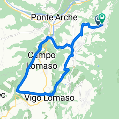
Poia Don Zio San Giovanni Lomasona - Poia Don Zio San Giovanni Lomasona
A cycling route starting in Ponte Arche, Trentino-Alto Adige, Italy.
Overview
About this route
Poia Don Zio San Giovanni Lomasona - Poia Don Zio San Giovanni Lomasona
- -:--
- Duration
- 55.5 km
- Distance
- 2,995 m
- Ascent
- 2,994 m
- Descent
- ---
- Avg. speed
- 1,469 m
- Max. altitude

Route quality
Waytypes & surfaces along the route
Waytypes
Track
40 km
(72 %)
Path
8.3 km
(15 %)
Surfaces
Paved
10.5 km
(19 %)
Unpaved
37.7 km
(68 %)
Ground
15.5 km
(28 %)
Gravel
11.7 km
(21 %)
Continue with Bikemap
Use, edit, or download this cycling route
You would like to ride Poia Don Zio San Giovanni Lomasona - Poia Don Zio San Giovanni Lomasona or customize it for your own trip? Here is what you can do with this Bikemap route:
Free features
- Save this route as favorite or in collections
- Copy & plan your own version of this route
- Sync your route with Garmin or Wahoo
Premium features
Free trial for 3 days, or one-time payment. More about Bikemap Premium.
- Navigate this route on iOS & Android
- Export a GPX / KML file of this route
- Create your custom printout (try it for free)
- Download this route for offline navigation
Discover more Premium features.
Get Bikemap PremiumFrom our community
Other popular routes starting in Ponte Arche
 3. Etape Comano Terme-Garda
- Distance
- 120.7 km
- Ascent
- 2,910 m
- Descent
- 3,270 m
- Location
- Ponte Arche, Trentino-Alto Adige, Italy
 Bycibus_PonteArche
- Distance
- 23.8 km
- Ascent
- 553 m
- Descent
- 882 m
- Location
- Ponte Arche, Trentino-Alto Adige, Italy
 1805. Passo della Morte
- Distance
- 21.7 km
- Ascent
- 916 m
- Descent
- 917 m
- Location
- Ponte Arche, Trentino-Alto Adige, Italy
 Tag 6 - Ponte Arche - Riva
- Distance
- 27 km
- Ascent
- 470 m
- Descent
- 802 m
- Location
- Ponte Arche, Trentino-Alto Adige, Italy
 Comano - Bivedo
- Distance
- 21.8 km
- Ascent
- 539 m
- Descent
- 538 m
- Location
- Ponte Arche, Trentino-Alto Adige, Italy
 Poia Don Zio San Giovanni Lomasona - Poia Don Zio San Giovanni Lomasona
- Distance
- 55.5 km
- Ascent
- 2,995 m
- Descent
- 2,994 m
- Location
- Ponte Arche, Trentino-Alto Adige, Italy
 Comano - Campo Lomaso
- Distance
- 9.9 km
- Ascent
- 269 m
- Descent
- 267 m
- Location
- Ponte Arche, Trentino-Alto Adige, Italy
 Da Via Lungo Sarca 67, Ponte Arche a Viale dei Tigli 21, Riva del Garda
- Distance
- 21.9 km
- Ascent
- 483 m
- Descent
- 802 m
- Location
- Ponte Arche, Trentino-Alto Adige, Italy
Open it in the app