

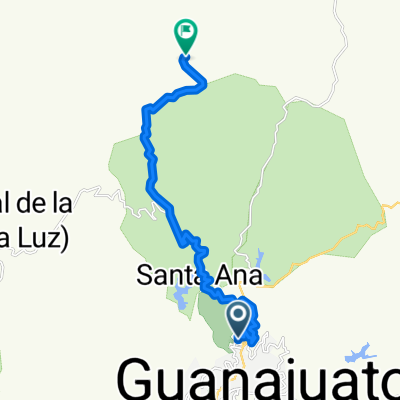
Guanajuato (San Javier)-Cañada de la Virgen
A cycling route starting in Guanajuato City, Guanajuato, Mexico.
Overview
About this route
Sierra de Santa Rosa, up to Cañada de la Virgen. From Picones onwards, the path is very difficult for bicycles (trails..). It's better to leave it at one of the last houses before Cañada.
- -:--
- Duration
- 27.2 km
- Distance
- 723 m
- Ascent
- 572 m
- Descent
- ---
- Avg. speed
- ---
- Max. altitude

Continue with Bikemap
Use, edit, or download this cycling route
You would like to ride Guanajuato (San Javier)-Cañada de la Virgen or customize it for your own trip? Here is what you can do with this Bikemap route:
Free features
- Save this route as favorite or in collections
- Copy & plan your own version of this route
- Sync your route with Garmin or Wahoo
Premium features
Free trial for 3 days, or one-time payment. More about Bikemap Premium.
- Navigate this route on iOS & Android
- Export a GPX / KML file of this route
- Create your custom printout (try it for free)
- Download this route for offline navigation
Discover more Premium features.
Get Bikemap PremiumFrom our community
Other popular routes starting in Guanajuato City
 Guanajuato (San Javier)-Mesacuata
- Distance
- 17 km
- Ascent
- 731 m
- Descent
- 270 m
- Location
- Guanajuato City, Guanajuato, Mexico
 Mineral del Cubo Guanajuato
- Distance
- 24.9 km
- Ascent
- 641 m
- Descent
- 636 m
- Location
- Guanajuato City, Guanajuato, Mexico
 J72 – Mardi 22 mars 2016 – Guanajuato – Dolores Hidalgo
- Distance
- 57.6 km
- Ascent
- 860 m
- Descent
- 947 m
- Location
- Guanajuato City, Guanajuato, Mexico
 Guanajuato (San Javier)-Santa Rosa por Concepción
- Distance
- 23 km
- Ascent
- 737 m
- Descent
- 513 m
- Location
- Guanajuato City, Guanajuato, Mexico
 Guanajuato (San Javier)-Santa Rosa por San Nicolas rumbo al Cubo
- Distance
- 43 km
- Ascent
- 976 m
- Descent
- 976 m
- Location
- Guanajuato City, Guanajuato, Mexico
 Guanajuato - Carretera panorámica
- Distance
- 26 km
- Ascent
- 412 m
- Descent
- 413 m
- Location
- Guanajuato City, Guanajuato, Mexico
 Guanajuato (San Javier)-Cañada de la Virgen
- Distance
- 27.2 km
- Ascent
- 723 m
- Descent
- 572 m
- Location
- Guanajuato City, Guanajuato, Mexico
 Guanajuato-El Cubo-Sn. Miguel-
- Distance
- 74.5 km
- Ascent
- 871 m
- Descent
- 1,034 m
- Location
- Guanajuato City, Guanajuato, Mexico
Open it in the app