

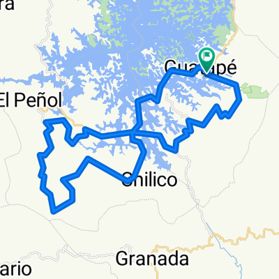
De Calle 8 1413, Peñol a Transversal 6 22a20, Peñol
A cycling route starting in Guatapé, Antioquia, Colombia.
Overview
About this route
- 2 h 29 min
- Duration
- 13.5 km
- Distance
- 892 m
- Ascent
- 898 m
- Descent
- 5.4 km/h
- Avg. speed
- 2,121 m
- Max. altitude

Continue with Bikemap
Use, edit, or download this cycling route
You would like to ride De Calle 8 1413, Peñol a Transversal 6 22a20, Peñol or customize it for your own trip? Here is what you can do with this Bikemap route:
Free features
- Save this route as favorite or in collections
- Copy & plan your own version of this route
- Sync your route with Garmin or Wahoo
Premium features
Free trial for 3 days, or one-time payment. More about Bikemap Premium.
- Navigate this route on iOS & Android
- Export a GPX / KML file of this route
- Create your custom printout (try it for free)
- Download this route for offline navigation
Discover more Premium features.
Get Bikemap PremiumFrom our community
Other popular routes starting in Guatapé
 Guatapé Festival de Rutas
- Distance
- 48.4 km
- Ascent
- 1,320 m
- Descent
- 1,318 m
- Location
- Guatapé, Antioquia, Colombia
 Giro de Rigo
- Distance
- 55 km
- Ascent
- 1,117 m
- Descent
- 1,117 m
- Location
- Guatapé, Antioquia, Colombia
 Guatapé Circuit
- Distance
- 33.5 km
- Ascent
- 1,009 m
- Descent
- 1,007 m
- Location
- Guatapé, Antioquia, Colombia
 De Calle 28, Granada a Calle 28, Granada
- Distance
- 28.5 km
- Ascent
- 709 m
- Descent
- 691 m
- Location
- Guatapé, Antioquia, Colombia
 KAYAK GUATAPE
- Distance
- 31.6 km
- Ascent
- 51 m
- Descent
- 55 m
- Location
- Guatapé, Antioquia, Colombia
 Guatapé-Rio Claro
- Distance
- 68.2 km
- Ascent
- 1,290 m
- Descent
- 2,866 m
- Location
- Guatapé, Antioquia, Colombia
 De El Peñol, Peñol a Penol - Guatape 51–91, Guatapé
- Distance
- 13.3 km
- Ascent
- 449 m
- Descent
- 525 m
- Location
- Guatapé, Antioquia, Colombia
 Lundi
Lundi- Distance
- 61.7 km
- Ascent
- 665 m
- Descent
- 1,471 m
- Location
- Guatapé, Antioquia, Colombia
Open it in the app