

Slovinsko - Rakousko 2011
A cycling route starting in Mekinje, Kamnik, Slovenia.
Overview
About this route
This route is only an overall view of the guided path. The individual stages have been processed separately. There are a total of 9 stages.
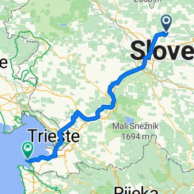
It starts in the Slovenian village of Kršič and ends in the German town of Passau at the Austrian-German border. Transportation to the starting point is by car, which accompanied us throughout the journey. Meetings with the accompanying car were always at previously agreed points marked in the individual stages (a sign with a red wrench). The roads are normally passable - it’s not any stunt driving. Nights are spent in camps under tents. I must, among other things, praise both Slovenian and Austrian drivers. They are absolutely considerate of cyclists, regardless of what car they own. We even encountered instances where they were able to follow us for several hundred meters to pass us safely. No honking, no gestures. We tied our bikes together in the camps, but I dare say that even if they were left out in the open, no one would take them. But you never know. And for what type of bike is this journey intended? I intentionally write for mountain including trekking bikes. A road bike could cover quite a bit of distance, but there are passages where you would feel sorry to use that road bike.
1st stage: Kršič - Luče 2nd stage: Luče - Maribor 3rd stage: Maribor - Graz 4th stage: Graz - Leoben 5th stage: Leoben - Murau 6th stage: Murau - Aigen Im Ennstal 7th stage: Aigen Im Ennstal - Grossraming 8th stage: Grossraming - Linz 9th stage: Linz - Passau
If this information is useful to anyone, I would be only too happy :-)
- -:--
- Duration
- 844.8 km
- Distance
- 2,712 m
- Ascent
- 2,849 m
- Descent
- ---
- Avg. speed
- ---
- Max. altitude

Route quality
Waytypes & surfaces along the route
Waytypes
Quiet road
287.2 km
(34 %)
Road
118.3 km
(14 %)
Surfaces
Paved
549.1 km
(65 %)
Unpaved
42.2 km
(5 %)
Asphalt
523.8 km
(62 %)
Gravel
33.8 km
(4 %)
Continue with Bikemap
Use, edit, or download this cycling route
You would like to ride Slovinsko - Rakousko 2011 or customize it for your own trip? Here is what you can do with this Bikemap route:
Free features
- Save this route as favorite or in collections
- Copy & plan your own version of this route
- Split it into stages to create a multi-day tour
- Sync your route with Garmin or Wahoo
Premium features
Free trial for 3 days, or one-time payment. More about Bikemap Premium.
- Navigate this route on iOS & Android
- Export a GPX / KML file of this route
- Create your custom printout (try it for free)
- Download this route for offline navigation
Discover more Premium features.
Get Bikemap PremiumFrom our community
Other popular routes starting in Mekinje
 Kamnik - Ušivec
- Distance
- 24.3 km
- Ascent
- 1,070 m
- Descent
- 52 m
- Location
- Mekinje, Kamnik, Slovenia
 Kamnik-Gornji grad-Kamnik
- Distance
- 99.4 km
- Ascent
- 875 m
- Descent
- 907 m
- Location
- Mekinje, Kamnik, Slovenia
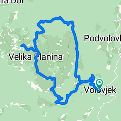
 Velika Planina MTB
- Distance
- 43.5 km
- Ascent
- 1,199 m
- Descent
- 1,197 m
- Location
- Mekinje, Kamnik, Slovenia
 Route from Sela pri Kamniku
- Distance
- 170 km
- Ascent
- 2,376 m
- Descent
- 2,869 m
- Location
- Mekinje, Kamnik, Slovenia
 velika planina
- Distance
- 8.6 km
- Ascent
- 616 m
- Descent
- 30 m
- Location
- Mekinje, Kamnik, Slovenia
 Slovinsko - Rakousko 2011
- Distance
- 844.8 km
- Ascent
- 2,712 m
- Descent
- 2,849 m
- Location
- Mekinje, Kamnik, Slovenia
 Na Veliko planino
- Distance
- 17.6 km
- Ascent
- 613 m
- Descent
- 614 m
- Location
- Mekinje, Kamnik, Slovenia
 Jelševa Trail in Brezje / Jelševa pot na Brezjah
- Distance
- 2.3 km
- Ascent
- 84 m
- Descent
- 84 m
- Location
- Mekinje, Kamnik, Slovenia
Open it in the app