
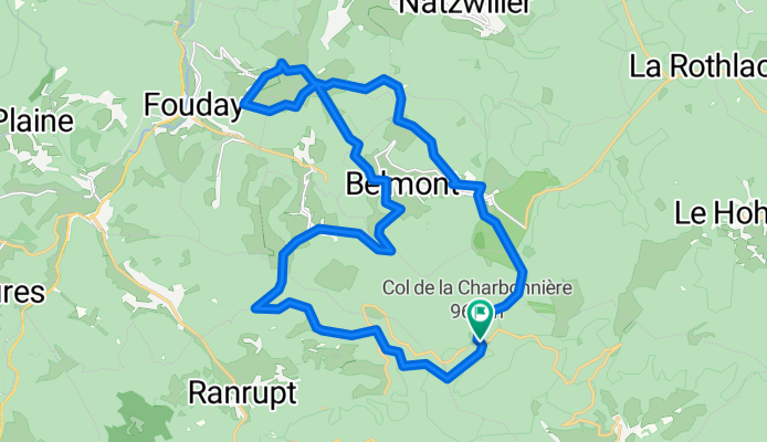
3_Charbo-Col de la Perheux -Champ du Feu
A cycling route starting in Villé, Grand Est, France.
Overview
About this route
Col de la Charbonnière Bellefosse Belmont Col de la Perheux Champ du Feu return Superb easy MTB ride, between 600 and 1100m altitude; almost always on small paths, with many views over the Bruche valley and the Val de Villé; several opportunities to stop for a drink.
- -:--
- Duration
- 25.2 km
- Distance
- 683 m
- Ascent
- 683 m
- Descent
- ---
- Avg. speed
- ---
- Max. altitude
Route quality
Waytypes & surfaces along the route
Waytypes
Track
12.1 km
(48 %)
Path
5.8 km
(23 %)
Surfaces
Unpaved
10.6 km
(42 %)
Ground
5.8 km
(23 %)
Unpaved (undefined)
2.5 km
(10 %)
Route highlights
Points of interest along the route
Point of interest after 7.6 km
Ferme auberge de Bellefosse
Point of interest after 11.2 km
Plusieurs bar-restaurants à Belmont
Point of interest after 25 km
Hotel-Restaurant du col de la Charbonnière
Continue with Bikemap
Use, edit, or download this cycling route
You would like to ride 3_Charbo-Col de la Perheux -Champ du Feu or customize it for your own trip? Here is what you can do with this Bikemap route:
Free features
- Save this route as favorite or in collections
- Copy & plan your own version of this route
- Sync your route with Garmin or Wahoo
Premium features
Free trial for 3 days, or one-time payment. More about Bikemap Premium.
- Navigate this route on iOS & Android
- Export a GPX / KML file of this route
- Create your custom printout (try it for free)
- Download this route for offline navigation
Discover more Premium features.
Get Bikemap PremiumFrom our community
Other popular routes starting in Villé
 4_Le tour de Breit'
- Distance
- 11.8 km
- Ascent
- 421 m
- Descent
- 421 m
- Location
- Villé, Grand Est, France
 essi3
essi3- Distance
- 19 km
- Ascent
- 590 m
- Descent
- 611 m
- Location
- Villé, Grand Est, France
 Tour Triembach über Col de Urbeis und Col de Steige
- Distance
- 34 km
- Ascent
- 678 m
- Descent
- 676 m
- Location
- Villé, Grand Est, France
 Vogesen 1
- Distance
- 79.5 km
- Ascent
- 1,555 m
- Descent
- 1,512 m
- Location
- Villé, Grand Est, France
 TP 20160912 VAR2 VILLE
- Distance
- 49.1 km
- Ascent
- 1,501 m
- Descent
- 1,510 m
- Location
- Villé, Grand Est, France
 Steinschloss - Champ du feu 25.5.19
- Distance
- 33.8 km
- Ascent
- 576 m
- Descent
- 574 m
- Location
- Villé, Grand Est, France
 3_Charbo-Col de la Perheux -Champ du Feu
- Distance
- 25.2 km
- Ascent
- 683 m
- Descent
- 683 m
- Location
- Villé, Grand Est, France
 1-balade des 5 chaumes
- Distance
- 34.3 km
- Ascent
- 773 m
- Descent
- 773 m
- Location
- Villé, Grand Est, France
Open it in the app