
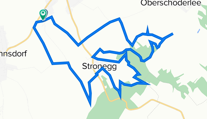
Idee Steinbergtrophy
A cycling route starting in Stronsdorf, Lower Austria, Austria.
Overview
About this route
- -:--
- Duration
- 13.6 km
- Distance
- 399 m
- Ascent
- 397 m
- Descent
- ---
- Avg. speed
- 357 m
- Max. altitude

Continue with Bikemap
Use, edit, or download this cycling route
You would like to ride Idee Steinbergtrophy or customize it for your own trip? Here is what you can do with this Bikemap route:
Free features
- Save this route as favorite or in collections
- Copy & plan your own version of this route
- Sync your route with Garmin or Wahoo
Premium features
Free trial for 3 days, or one-time payment. More about Bikemap Premium.
- Navigate this route on iOS & Android
- Export a GPX / KML file of this route
- Create your custom printout (try it for free)
- Download this route for offline navigation
Discover more Premium features.
Get Bikemap PremiumFrom our community
Other popular routes starting in Stronsdorf
 Egenburg-Pulkau Retz
- Distance
- 92.4 km
- Ascent
- 353 m
- Descent
- 354 m
- Location
- Stronsdorf, Lower Austria, Austria
 Sitzendorf a.d. Schmida Runde
- Distance
- 63 km
- Ascent
- 374 m
- Descent
- 374 m
- Location
- Stronsdorf, Lower Austria, Austria
 Buschberg
- Distance
- 17 km
- Ascent
- 329 m
- Descent
- 68 m
- Location
- Stronsdorf, Lower Austria, Austria
 Idee Steinbergtrophy
- Distance
- 13.6 km
- Ascent
- 399 m
- Descent
- 397 m
- Location
- Stronsdorf, Lower Austria, Austria
 Radwantertag 2022_Idee lang
- Distance
- 48.7 km
- Ascent
- 379 m
- Descent
- 380 m
- Location
- Stronsdorf, Lower Austria, Austria
 Idee Steinbergtrophy_2022_neu
- Distance
- 16.6 km
- Ascent
- 432 m
- Descent
- 430 m
- Location
- Stronsdorf, Lower Austria, Austria
 Radwantertag 2022_Idee kurz
- Distance
- 34.5 km
- Ascent
- 275 m
- Descent
- 276 m
- Location
- Stronsdorf, Lower Austria, Austria
 Buschberg 2
- Distance
- 30.8 km
- Ascent
- 415 m
- Descent
- 415 m
- Location
- Stronsdorf, Lower Austria, Austria
Open it in the app