

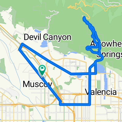
Shadow Hills Drive 2652, San Bernardino to Shadow Hills Drive 2665, San Bernardino
A cycling route starting in Muscoy, California, United States.
Overview
About this route
- 1 h 24 min
- Duration
- 11.5 km
- Distance
- 111 m
- Ascent
- 112 m
- Descent
- 8.1 km/h
- Avg. speed
- 590 m
- Max. altitude

Route photos


Route quality
Waytypes & surfaces along the route
Waytypes
Quiet road
6 km
(52 %)
Access road
1.5 km
(13 %)
Surfaces
Paved
5.8 km
(51 %)
Asphalt
5.8 km
(51 %)
Undefined
5.6 km
(49 %)
Continue with Bikemap
Use, edit, or download this cycling route
You would like to ride Shadow Hills Drive 2652, San Bernardino to Shadow Hills Drive 2665, San Bernardino or customize it for your own trip? Here is what you can do with this Bikemap route:
Free features
- Save this route as favorite or in collections
- Copy & plan your own version of this route
- Sync your route with Garmin or Wahoo
Premium features
Free trial for 3 days, or one-time payment. More about Bikemap Premium.
- Navigate this route on iOS & Android
- Export a GPX / KML file of this route
- Create your custom printout (try it for free)
- Download this route for offline navigation
Discover more Premium features.
Get Bikemap PremiumFrom our community
Other popular routes starting in Muscoy
 CSUSB kleine Trainingsrunde?
- Distance
- 32 km
- Ascent
- 902 m
- Descent
- 902 m
- Location
- Muscoy, California, United States
 training, kurz, knackig/retour
- Distance
- 29.6 km
- Ascent
- 711 m
- Descent
- 676 m
- Location
- Muscoy, California, United States
 Cruising
- Distance
- 39.3 km
- Ascent
- 906 m
- Descent
- 905 m
- Location
- Muscoy, California, United States
 Rim of the World Hwy bis Lake Arrowhead
- Distance
- 36.9 km
- Ascent
- 1,391 m
- Descent
- 279 m
- Location
- Muscoy, California, United States
 CSUSB - Lake Arrowhead - Running Springs - CSUSB
- Distance
- 75.3 km
- Ascent
- 1,579 m
- Descent
- 1,632 m
- Location
- Muscoy, California, United States
 Rosena Master Loop
- Distance
- 31.2 km
- Ascent
- 310 m
- Descent
- 294 m
- Location
- Muscoy, California, United States
 1700 W Highland Ave, San Bernardino to 1124 N Yucca Ave, Rialto
- Distance
- 8.1 km
- Ascent
- 115 m
- Descent
- 80 m
- Location
- Muscoy, California, United States
 Home to school
- Distance
- 19.6 km
- Ascent
- 134 m
- Descent
- 220 m
- Location
- Muscoy, California, United States
Open it in the app