

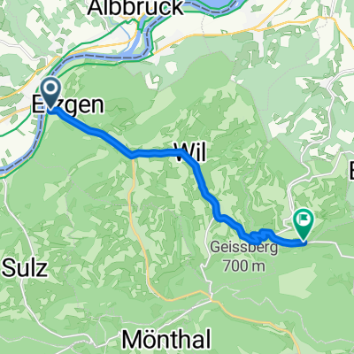
Route nach Mettauerberg 3287.1, Mettau
A cycling route starting in Schwaderloch, Canton of Aargau, Switzerland.
Overview
About this route
- 15 min
- Duration
- 3.3 km
- Distance
- 129 m
- Ascent
- 64 m
- Descent
- 13.3 km/h
- Avg. speed
- 496 m
- Max. altitude
Route photos


Route quality
Waytypes & surfaces along the route
Waytypes
Track
3.3 km
(100 %)
Surfaces
Paved
0 km
(1 %)
Unpaved
3.3 km
(100 %)
Gravel
2.9 km
(86 %)
Ground
0.4 km
(13 %)
Continue with Bikemap
Use, edit, or download this cycling route
You would like to ride Route nach Mettauerberg 3287.1, Mettau or customize it for your own trip? Here is what you can do with this Bikemap route:
Free features
- Save this route as favorite or in collections
- Copy & plan your own version of this route
- Sync your route with Garmin or Wahoo
Premium features
Free trial for 3 days, or one-time payment. More about Bikemap Premium.
- Navigate this route on iOS & Android
- Export a GPX / KML file of this route
- Create your custom printout (try it for free)
- Download this route for offline navigation
Discover more Premium features.
Get Bikemap PremiumFrom our community
Other popular routes starting in Schwaderloch
 15_07_16 - Albtal/Wehratal + Dinkelberg
- Distance
- 93.1 km
- Ascent
- 981 m
- Descent
- 1,029 m
- Location
- Schwaderloch, Canton of Aargau, Switzerland
 Albrucht onwards
- Distance
- 52.8 km
- Ascent
- 395 m
- Descent
- 345 m
- Location
- Schwaderloch, Canton of Aargau, Switzerland
 Albert - Rheinfall Fußbrücke 66km
- Distance
- 65.6 km
- Ascent
- 660 m
- Descent
- 576 m
- Location
- Schwaderloch, Canton of Aargau, Switzerland
 messfahrt PW
- Distance
- 8.7 km
- Ascent
- 314 m
- Descent
- 21 m
- Location
- Schwaderloch, Canton of Aargau, Switzerland
 De Landstrasse 1362, Mettauertal à Kaltenbacherstrasse 4, Stein am Rhein
- Distance
- 76.9 km
- Ascent
- 642 m
- Descent
- 532 m
- Location
- Schwaderloch, Canton of Aargau, Switzerland
 Hauptstrasse 71, Schwaderloch nach Hauptstrasse 7 16, Laufenburg
- Distance
- 8.9 km
- Ascent
- 135 m
- Descent
- 130 m
- Location
- Schwaderloch, Canton of Aargau, Switzerland
 Albtal komplett (Albbr. - St.Blasien)
- Distance
- 24.7 km
- Ascent
- 570 m
- Descent
- 144 m
- Location
- Schwaderloch, Canton of Aargau, Switzerland
 Hauptstrasse 73, Schwaderloch to Giessenstraße 26, Bad Säckingen
- Distance
- 19.2 km
- Ascent
- 95 m
- Descent
- 115 m
- Location
- Schwaderloch, Canton of Aargau, Switzerland
Open it in the app