

NC Bike Route 2 More Direct
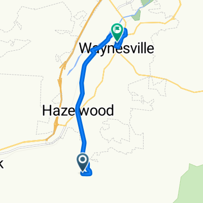
A cycling route starting in Hazelwood, North Carolina, United States.
Overview
About this route
NC Bike Route 2 Parkway Alternative with more services
- -:--
- Duration
- 54 km
- Distance
- 728 m
- Ascent
- 1,109 m
- Descent
- ---
- Avg. speed
- 1,021 m
- Max. altitude

Route quality
Waytypes & surfaces along the route
Waytypes
Busy road
20.9 km
(39 %)
Quiet road
11.9 km
(22 %)
Surfaces
Paved
7.5 km
(14 %)
Unpaved
0 km
(<1 %)
Paved (undefined)
4.3 km
(8 %)
Asphalt
3.2 km
(6 %)
Continue with Bikemap
Use, edit, or download this cycling route
You would like to ride NC Bike Route 2 More Direct or customize it for your own trip? Here is what you can do with this Bikemap route:
Free features
- Save this route as favorite or in collections
- Copy & plan your own version of this route
- Sync your route with Garmin or Wahoo
Premium features
Free trial for 3 days, or one-time payment. More about Bikemap Premium.
- Navigate this route on iOS & Android
- Export a GPX / KML file of this route
- Create your custom printout (try it for free)
- Download this route for offline navigation
Discover more Premium features.
Get Bikemap PremiumFrom our community
Other popular routes starting in Hazelwood
 Moderate route in Waynesville
- Distance
- 7.6 km
- Ascent
- 106 m
- Descent
- 200 m
- Location
- Hazelwood, North Carolina, United States
 NC Bike Route 2 More Direct
- Distance
- 54 km
- Ascent
- 728 m
- Descent
- 1,109 m
- Location
- Hazelwood, North Carolina, United States
 HCBR1
HCBR1- Distance
- 17.2 km
- Ascent
- 317 m
- Descent
- 317 m
- Location
- Hazelwood, North Carolina, United States
 HCBR74
- Distance
- 7.2 km
- Ascent
- 93 m
- Descent
- 103 m
- Location
- Hazelwood, North Carolina, United States
 ToA19 Devils Corthouse
- Distance
- 18.5 km
- Ascent
- 850 m
- Descent
- 120 m
- Location
- Hazelwood, North Carolina, United States
 blue ridge entre cherokee et asheville
- Distance
- 37.3 km
- Ascent
- 736 m
- Descent
- 736 m
- Location
- Hazelwood, North Carolina, United States
 13-3-2011 Balsam - Cherokee
- Distance
- 54.7 km
- Ascent
- 462 m
- Descent
- 778 m
- Location
- Hazelwood, North Carolina, United States
 Blue Ridge Crest Views
- Distance
- 41.8 km
- Ascent
- 720 m
- Descent
- 738 m
- Location
- Hazelwood, North Carolina, United States
Open it in the app