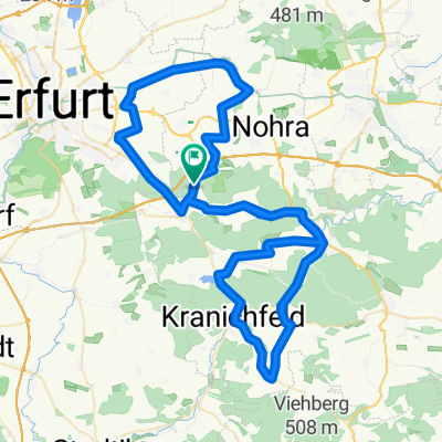
von der radwegschutzhütte klettbach -nauendorf zum riechheimer berg
A cycling route starting in Klettbach, Free State of Thuringia, Germany.
Overview
About this route
von der neuen radwegschutzhütte zwischen klettbach -nauendorf zum riechheimer berg
- -:--
- Duration
- 4.5 km
- Distance
- 180 m
- Ascent
- 32 m
- Descent
- ---
- Avg. speed
- ---
- Avg. speed
Route quality
Waytypes & surfaces along the route
Waytypes
Track
4.3 km
(95 %)
Access road
0.2 km
(5 %)
Surfaces
Paved
0.4 km
(9 %)
Unpaved
4.1 km
(91 %)
Gravel
3.5 km
(78 %)
Ground
0.6 km
(13 %)
Continue with Bikemap
Use, edit, or download this cycling route
You would like to ride von der radwegschutzhütte klettbach -nauendorf zum riechheimer berg or customize it for your own trip? Here is what you can do with this Bikemap route:
Free features
- Save this route as favorite or in collections
- Copy & plan your own version of this route
- Sync your route with Garmin or Wahoo
Premium features
Free trial for 3 days, or one-time payment. More about Bikemap Premium.
- Navigate this route on iOS & Android
- Export a GPX / KML file of this route
- Create your custom printout (try it for free)
- Download this route for offline navigation
Discover more Premium features.
Get Bikemap PremiumFrom our community
Other popular routes starting in Klettbach
- von der radwegschutzhütte klettbach -nauendorf zum riechheimer berg
- Distance
- 4.5 km
- Ascent
- 180 m
- Descent
- 32 m
- Location
- Klettbach, Free State of Thuringia, Germany
- Ilm - Saale -Ilm - Unstrut (E-Bike)
- Distance
- 154.2 km
- Ascent
- 1,204 m
- Descent
- 1,197 m
- Location
- Klettbach, Free State of Thuringia, Germany
- Vom Thüringer Land zum Ostseestrand 1
- Distance
- 131.9 km
- Ascent
- 798 m
- Descent
- 859 m
- Location
- Klettbach, Free State of Thuringia, Germany
- Zum Garten der Stille in Plinz
- Distance
- 72.2 km
- Ascent
- 888 m
- Descent
- 888 m
- Location
- Klettbach, Free State of Thuringia, Germany
- Hoch hinaus am Tag der Einheit
- Distance
- 125.3 km
- Ascent
- 1,480 m
- Descent
- 1,484 m
- Location
- Klettbach, Free State of Thuringia, Germany
- hohenfelden
- Distance
- 28.8 km
- Ascent
- 552 m
- Descent
- 451 m
- Location
- Klettbach, Free State of Thuringia, Germany
- 2020 Inselsbergtour
- Distance
- 165.9 km
- Ascent
- 2,032 m
- Descent
- 2,026 m
- Location
- Klettbach, Free State of Thuringia, Germany
- KlettbachBrocken
- Distance
- 331.4 km
- Ascent
- 1,339 m
- Descent
- 1,339 m
- Location
- Klettbach, Free State of Thuringia, Germany
Open it in the app