
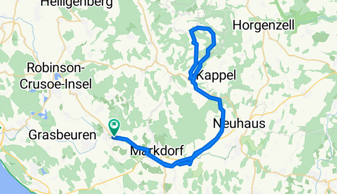
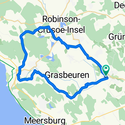
Von Bermatingen über Markdorf nach Urnau zu Rundfahrt am Höchsten (Limpach)
A cycling route starting in Bermatingen, Baden-Wurttemberg, Germany.
Overview
About this route
Following the bike route signs from Bermatingen through Markdorf, Leimbach, and Hepbach towards Oberteuringen. After Stadel, leave the federal road and follow the signs to Fuchstobel. In the forest, at the inn, turn left and follow the bike route signs to the main road. On this road, pass through Urnau. At the village exit, turn right, pass the Stoppomat and head up the road to Wattenburg. At the exit of Wattenburg, take the right path to shortcut the bend in the road towards Limpach. At the end of the path, turn right and continue on the road to Limpacj. It is worth making a detour to the inn Mohren to visit the rectory for a remarkable view of Lake Constance. From the inn, continue up the road to Höge. In Höge, turn right and descend through Burg to Benistobel. Attention: From Burg to Benistobel, the gravel path is steep. Follow along the Rotach to Schönemühle and then return to Bermatingen via Urnau.
- -:--
- Duration
- 43.5 km
- Distance
- 358 m
- Ascent
- 358 m
- Descent
- ---
- Avg. speed
- ---
- Max. altitude

Route quality
Waytypes & surfaces along the route
Waytypes
Quiet road
16.1 km
(37 %)
Road
12.2 km
(28 %)
Surfaces
Paved
41.3 km
(95 %)
Unpaved
1.3 km
(3 %)
Asphalt
41.3 km
(95 %)
Gravel
0.9 km
(2 %)
Continue with Bikemap
Use, edit, or download this cycling route
You would like to ride Von Bermatingen über Markdorf nach Urnau zu Rundfahrt am Höchsten (Limpach) or customize it for your own trip? Here is what you can do with this Bikemap route:
Free features
- Save this route as favorite or in collections
- Copy & plan your own version of this route
- Sync your route with Garmin or Wahoo
Premium features
Free trial for 3 days, or one-time payment. More about Bikemap Premium.
- Navigate this route on iOS & Android
- Export a GPX / KML file of this route
- Create your custom printout (try it for free)
- Download this route for offline navigation
Discover more Premium features.
Get Bikemap PremiumFrom our community
Other popular routes starting in Bermatingen
 Wittenhofen - Salem - Runde
- Distance
- 46.7 km
- Ascent
- 490 m
- Descent
- 486 m
- Location
- Bermatingen, Baden-Wurttemberg, Germany
 Panorama Rundfahrt von Bermatingen mit Salemer Tal, Überlinger See, Säntis, Friedrichshafen und Gehrenberg
- Distance
- 35.8 km
- Ascent
- 328 m
- Descent
- 327 m
- Location
- Bermatingen, Baden-Wurttemberg, Germany
 Flache Runde von Bermatingen über Markdorf, Bürgberg, Reute, Breitenbach und Ahausen
- Distance
- 21.1 km
- Ascent
- 153 m
- Descent
- 153 m
- Location
- Bermatingen, Baden-Wurttemberg, Germany
 Rund um Deggenhausen (Höchsten)
- Distance
- 49.5 km
- Ascent
- 572 m
- Descent
- 500 m
- Location
- Bermatingen, Baden-Wurttemberg, Germany
 Bermatingen Rundwanderung
- Distance
- 9.2 km
- Ascent
- 223 m
- Descent
- 223 m
- Location
- Bermatingen, Baden-Wurttemberg, Germany
 Rundfahrt von Bermatingen über Salem - Affenberg - Uhldingen - Mühlhofen - Schiggendorf - Auhausen
- Distance
- 25.7 km
- Ascent
- 143 m
- Descent
- 146 m
- Location
- Bermatingen, Baden-Wurttemberg, Germany
 Bermatingen - Leutkirch - Lellwangen - Wittenhofen - Shoren - Grünwangen - Neufrach - Mimmenahusen
- Distance
- 32.3 km
- Ascent
- 416 m
- Descent
- 413 m
- Location
- Bermatingen, Baden-Wurttemberg, Germany
 Rundfahrt von Bermatingen über Altenbeuren, Beuren, Leutstetten, Frickingen, Altheim und Buggensegel
- Distance
- 35.8 km
- Ascent
- 268 m
- Descent
- 276 m
- Location
- Bermatingen, Baden-Wurttemberg, Germany
Open it in the app