

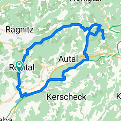
Waltendorfer Hauptstraße 196, Graz to Waltendorfer Hauptstraße 184, Graz
A cycling route starting in Hart bei Graz, Styria, Austria.
Overview
About this route
- 50 min
- Duration
- 7.6 km
- Distance
- 166 m
- Ascent
- 163 m
- Descent
- 9.1 km/h
- Avg. speed
- 540 m
- Max. altitude

Route photos


Route quality
Waytypes & surfaces along the route
Waytypes
Quiet road
4.6 km
(60 %)
Pedestrian area
1.4 km
(18 %)
Surfaces
Paved
7.3 km
(96 %)
Asphalt
7.3 km
(96 %)
Undefined
0.3 km
(4 %)
Continue with Bikemap
Use, edit, or download this cycling route
You would like to ride Waltendorfer Hauptstraße 196, Graz to Waltendorfer Hauptstraße 184, Graz or customize it for your own trip? Here is what you can do with this Bikemap route:
Free features
- Save this route as favorite or in collections
- Copy & plan your own version of this route
- Sync your route with Garmin or Wahoo
Premium features
Free trial for 3 days, or one-time payment. More about Bikemap Premium.
- Navigate this route on iOS & Android
- Export a GPX / KML file of this route
- Create your custom printout (try it for free)
- Download this route for offline navigation
Discover more Premium features.
Get Bikemap PremiumFrom our community
Other popular routes starting in Hart bei Graz
 Waltendorf - Dreitälerweg (Hönigthal - Lembachtal - Tomschetal)
- Distance
- 25.3 km
- Ascent
- 386 m
- Descent
- 386 m
- Location
- Hart bei Graz, Styria, Austria
 Fasangasse, Hart bei Graz nach Fasangasse, Hart bei Graz
- Distance
- 19 km
- Ascent
- 432 m
- Descent
- 430 m
- Location
- Hart bei Graz, Styria, Austria
 Fahrwoche 2014 3.Ausfahrt
- Distance
- 90.1 km
- Ascent
- 738 m
- Descent
- 814 m
- Location
- Hart bei Graz, Styria, Austria
 waldschachersee
- Distance
- 39.3 km
- Ascent
- 160 m
- Descent
- 252 m
- Location
- Hart bei Graz, Styria, Austria
 Pauls Schöckl classic
- Distance
- 56.5 km
- Ascent
- 962 m
- Descent
- 962 m
- Location
- Hart bei Graz, Styria, Austria
 R2_Hausman_Schemmerl
- Distance
- 46.2 km
- Ascent
- 649 m
- Descent
- 650 m
- Location
- Hart bei Graz, Styria, Austria
 Waltendorfer Hauptstraße 196, Graz to Waltendorfer Hauptstraße 184, Graz
- Distance
- 7.6 km
- Ascent
- 166 m
- Descent
- 163 m
- Location
- Hart bei Graz, Styria, Austria
 Koglbauerweg nach Strada del roccolino
- Distance
- 566 km
- Ascent
- 5,887 m
- Descent
- 6,223 m
- Location
- Hart bei Graz, Styria, Austria
Open it in the app