

Der heilige Kral
A cycling route starting in Hilzingen, Baden-Wurttemberg, Germany.
Overview
About this route
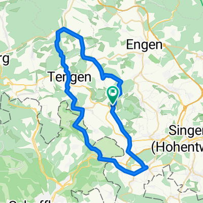
For a true Hegauer, this route is a must. Here you drive through a very good mix of Randen, Rhine and Schiener Berg. The route starts fairly flat up to Biber. Ideal for warming up. In Biber, a really long climb begins up into the Randen at Wiechs. From here, one of the most beautiful descents begins. Here is also the world-famous descent 'The Holy Grail'. Upon arriving in Schaffhausen, a very nice trail along the Rhine begins. In common parlance, it is called Rhywanderweg. Here you can expect beautiful little technical sections like roots and small wooden bridges. In Diesenhofen, you cross the beautiful wooden bridge towards Gailingen. Everyone surely knows the climb to Gailingen now. But not everyone knows the right trail up to the Schmieder Clinics. Once at the top, you ride along the ridge of Rauhenberg to the east. At the most eastern point, there are two very nice mini descents. To crown it all, there’s another ride up to Schiener Berg to Herrentisch. With a very rewarding descent called 'The Canyon'. After that, there is a relaxed ride through Gattmadingen back to Hilzingen.
- -:--
- Duration
- 63.8 km
- Distance
- 969 m
- Ascent
- 969 m
- Descent
- ---
- Avg. speed
- ---
- Max. altitude
Route highlights
Points of interest along the route
Point of interest after 18.1 km
Abfahrt: "Der heilige Kral"
Point of interest after 51.7 km
Herrentisch
Point of interest after 52.5 km
Abfahrt: "Der Canyon"
Continue with Bikemap
Use, edit, or download this cycling route
You would like to ride Der heilige Kral or customize it for your own trip? Here is what you can do with this Bikemap route:
Free features
- Save this route as favorite or in collections
- Copy & plan your own version of this route
- Sync your route with Garmin or Wahoo
Premium features
Free trial for 3 days, or one-time payment. More about Bikemap Premium.
- Navigate this route on iOS & Android
- Export a GPX / KML file of this route
- Create your custom printout (try it for free)
- Download this route for offline navigation
Discover more Premium features.
Get Bikemap PremiumFrom our community
Other popular routes starting in Hilzingen
 Hilzingen, Wutachtal, Schwarzwaldpanoramastraße, Klettgau, Rhein CLONED FROM ROUTE 111674
- Distance
- 142.6 km
- Ascent
- 1,261 m
- Descent
- 1,261 m
- Location
- Hilzingen, Baden-Wurttemberg, Germany
 Binningen - Höri - Binningen
- Distance
- 67.9 km
- Ascent
- 317 m
- Descent
- 317 m
- Location
- Hilzingen, Baden-Wurttemberg, Germany
 Nordseite des Schienerberges
- Distance
- 51.6 km
- Ascent
- 1,121 m
- Descent
- 1,121 m
- Location
- Hilzingen, Baden-Wurttemberg, Germany
 Der heilige Kral
- Distance
- 63.8 km
- Ascent
- 969 m
- Descent
- 969 m
- Location
- Hilzingen, Baden-Wurttemberg, Germany
 Wutach-Tal
- Distance
- 100.3 km
- Ascent
- 1,373 m
- Descent
- 1,380 m
- Location
- Hilzingen, Baden-Wurttemberg, Germany
 Binningen - Leipferdingen - Tengen - Bibertal - Gottmadingen - Binningen
- Distance
- 47.1 km
- Ascent
- 538 m
- Descent
- 538 m
- Location
- Hilzingen, Baden-Wurttemberg, Germany
 Um den Hohenstoffeln (kleine Tour)
- Distance
- 16.4 km
- Ascent
- 190 m
- Descent
- 148 m
- Location
- Hilzingen, Baden-Wurttemberg, Germany
 Höritour
- Distance
- 58.7 km
- Ascent
- 400 m
- Descent
- 400 m
- Location
- Hilzingen, Baden-Wurttemberg, Germany
Open it in the app