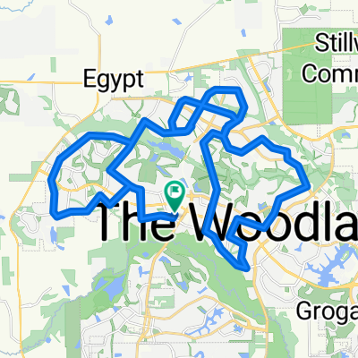
taliaferro
A cycling route starting in The Woodlands, Texas, United States of America.
Overview
About this route
hilly but fun with great safe roads and awesome viewsÂ
- -:--
- Duration
- 103.5 km
- Distance
- 781 m
- Ascent
- 781 m
- Descent
- ---
- Avg. speed
- 129 m
- Avg. speed
Route quality
Waytypes & surfaces along the route
Waytypes
Busy road
55.2 km
(53 %)
Quiet road
23.8 km
(23 %)
Surfaces
Paved
52 km
(50 %)
Paved (undefined)
49.4 km
(48 %)
Asphalt
2.4 km
(2 %)
Route highlights
Points of interest along the route
Point of interest after 74.8 km
rest stop
Continue with Bikemap
Use, edit, or download this cycling route
You would like to ride taliaferro or customize it for your own trip? Here is what you can do with this Bikemap route:
Free features
- Save this route as favorite or in collections
- Copy & plan your own version of this route
- Sync your route with Garmin or Wahoo
Premium features
Free trial for 3 days, or one-time payment. More about Bikemap Premium.
- Navigate this route on iOS & Android
- Export a GPX / KML file of this route
- Create your custom printout (try it for free)
- Download this route for offline navigation
Discover more Premium features.
Get Bikemap PremiumFrom our community
Other popular routes starting in The Woodlands
- 49 E Torchpine Cir, Spring to 4061–4099 S Panther Creek Dr, Spring
- Distance
- 1.1 km
- Ascent
- 3 m
- Descent
- 4 m
- Location
- The Woodlands, Texas, United States of America
- Texas Ironman for Zwift
- Distance
- 1,422.2 km
- Ascent
- 234 m
- Descent
- 281 m
- Location
- The Woodlands, Texas, United States of America
- Starbucks to Home
- Distance
- 5.7 km
- Ascent
- 12 m
- Descent
- 20 m
- Location
- The Woodlands, Texas, United States of America
- Beast Mode 2
- Distance
- 52.7 km
- Ascent
- 228 m
- Descent
- 228 m
- Location
- The Woodlands, Texas, United States of America
- taliaferro
- Distance
- 103.5 km
- Ascent
- 781 m
- Descent
- 781 m
- Location
- The Woodlands, Texas, United States of America
- branch great ride
- Distance
- 14.8 km
- Ascent
- 232 m
- Descent
- 237 m
- Location
- The Woodlands, Texas, United States of America
- The Woodlands
- Distance
- 54 km
- Ascent
- 107 m
- Descent
- 114 m
- Location
- The Woodlands, Texas, United States of America
- Moderate route in Spring
- Distance
- 65.6 km
- Ascent
- 347 m
- Descent
- 345 m
- Location
- The Woodlands, Texas, United States of America