

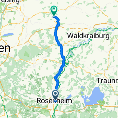
Von Rosenheim auf die Ratzinger-Höh
A cycling route starting in Rosenheim, Bavaria, Germany.
Overview
About this route
it was hot!
- -:--
- Duration
- 54.2 km
- Distance
- 434 m
- Ascent
- 433 m
- Descent
- ---
- Avg. speed
- ---
- Max. altitude

Route highlights
Points of interest along the route

Photo after 12.7 km
Urwald

Photo after 25.7 km
Point of interest after 26.1 km
Trail

Photo after 28.7 km
Ist die nicht niedlich?
Point of interest after 40.7 km
6,5 km² Plantschbecken
Continue with Bikemap
Use, edit, or download this cycling route
You would like to ride Von Rosenheim auf die Ratzinger-Höh or customize it for your own trip? Here is what you can do with this Bikemap route:
Free features
- Save this route as favorite or in collections
- Copy & plan your own version of this route
- Sync your route with Garmin or Wahoo
Premium features
Free trial for 3 days, or one-time payment. More about Bikemap Premium.
- Navigate this route on iOS & Android
- Export a GPX / KML file of this route
- Create your custom printout (try it for free)
- Download this route for offline navigation
Discover more Premium features.
Get Bikemap PremiumFrom our community
Other popular routes starting in Rosenheim
 Girolibero:Chiemsee
- Distance
- 201 km
- Ascent
- 432 m
- Descent
- 432 m
- Location
- Rosenheim, Bavaria, Germany
 Oberland-Irschenberg Runde
- Distance
- 105.4 km
- Ascent
- 500 m
- Descent
- 500 m
- Location
- Rosenheim, Bavaria, Germany
 Kirchdorf am Inn - Rosenheim (Zellerhornstrasse)
- Distance
- 8.8 km
- Ascent
- 22 m
- Descent
- 14 m
- Location
- Rosenheim, Bavaria, Germany
 Rosenheim to ChiemSee
- Distance
- 38.6 km
- Ascent
- 267 m
- Descent
- 196 m
- Location
- Rosenheim, Bavaria, Germany
 Die schönsten Straßen im Chiemgau 1
- Distance
- 61.2 km
- Ascent
- 908 m
- Descent
- 908 m
- Location
- Rosenheim, Bavaria, Germany
 Von Rosenheim auf die Ratzinger-Höh
- Distance
- 54.2 km
- Ascent
- 434 m
- Descent
- 433 m
- Location
- Rosenheim, Bavaria, Germany
 Rosenheim - Taufkirchen
- Distance
- 64.3 km
- Ascent
- 595 m
- Descent
- 555 m
- Location
- Rosenheim, Bavaria, Germany
 Ultimative Transalp - Tour de France
- Distance
- 496.7 km
- Ascent
- 1,033 m
- Descent
- 1,476 m
- Location
- Rosenheim, Bavaria, Germany
Open it in the app