

De Route de Taillebourg 2, Mazeray à Rue Thomas Edison 6, Dolus-d'Oléron
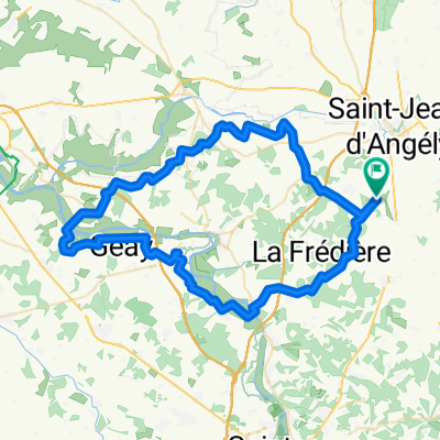
A cycling route starting in Saint-Jean-d'Angély, Nouvelle-Aquitaine, France.
Overview
About this route
- 4 h 26 min
- Duration
- 71.9 km
- Distance
- 149 m
- Ascent
- 217 m
- Descent
- 16.2 km/h
- Avg. speed
- 124 m
- Max. altitude

Route quality
Waytypes & surfaces along the route
Waytypes
Quiet road
23.7 km
(33 %)
Road
19.4 km
(27 %)
Surfaces
Paved
31.6 km
(44 %)
Unpaved
13.7 km
(19 %)
Asphalt
31.6 km
(44 %)
Gravel
13.7 km
(19 %)
Undefined
26.6 km
(37 %)
Continue with Bikemap
Use, edit, or download this cycling route
You would like to ride De Route de Taillebourg 2, Mazeray à Rue Thomas Edison 6, Dolus-d'Oléron or customize it for your own trip? Here is what you can do with this Bikemap route:
Free features
- Save this route as favorite or in collections
- Copy & plan your own version of this route
- Sync your route with Garmin or Wahoo
Premium features
Free trial for 3 days, or one-time payment. More about Bikemap Premium.
- Navigate this route on iOS & Android
- Export a GPX / KML file of this route
- Create your custom printout (try it for free)
- Download this route for offline navigation
Discover more Premium features.
Get Bikemap PremiumFrom our community
Other popular routes starting in Saint-Jean-d'Angély
 Facile à conduire Loulay
- Distance
- 15.5 km
- Ascent
- 86 m
- Descent
- 85 m
- Location
- Saint-Jean-d'Angély, Nouvelle-Aquitaine, France
 Day 19 - Lucca to London - Saint Jean d'Angely to Fontenay le Comte
- Distance
- 80.2 km
- Ascent
- 283 m
- Descent
- 237 m
- Location
- Saint-Jean-d'Angély, Nouvelle-Aquitaine, France
 Itinéraire confortable en Loulay
- Distance
- 21.6 km
- Ascent
- 100 m
- Descent
- 104 m
- Location
- Saint-Jean-d'Angély, Nouvelle-Aquitaine, France
 Voie comme un escargot dans Loulay
- Distance
- 11.7 km
- Ascent
- 56 m
- Descent
- 58 m
- Location
- Saint-Jean-d'Angély, Nouvelle-Aquitaine, France
 De Quai de Bernouet 26, Saint-Jean-d'Angély à Rue de Ganochaud 67, Ternant
- Distance
- 3.3 km
- Ascent
- 61 m
- Descent
- 6 m
- Location
- Saint-Jean-d'Angély, Nouvelle-Aquitaine, France
 circuit #6 zoodyssée
- Distance
- 76.6 km
- Ascent
- 442 m
- Descent
- 445 m
- Location
- Saint-Jean-d'Angély, Nouvelle-Aquitaine, France
 étape ride #6 Taillebourg maya châteaux
- Distance
- 70.3 km
- Ascent
- 394 m
- Descent
- 390 m
- Location
- Saint-Jean-d'Angély, Nouvelle-Aquitaine, France
 De Route de Taillebourg 2, Mazeray à Rue Thomas Edison 6, Dolus-d'Oléron
- Distance
- 71.9 km
- Ascent
- 149 m
- Descent
- 217 m
- Location
- Saint-Jean-d'Angély, Nouvelle-Aquitaine, France
Open it in the app