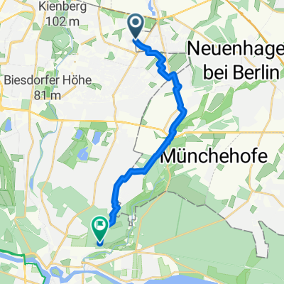
Mahlsdorf/Hönow/Strausberg/Waldsieversdorf/Müncheberg/Fürstenwalde/Schmöckwitz/Köpenick/Mahlsdorf
A cycling route starting in Hellersdorf, Land Berlin, Germany.
Overview
About this route
- -:--
- Duration
- 125.3 km
- Distance
- 200 m
- Ascent
- 200 m
- Descent
- ---
- Avg. speed
- ---
- Avg. speed
Route quality
Waytypes & surfaces along the route
Waytypes
Busy road
39.5 km
(32 %)
Path
24.3 km
(19 %)
Surfaces
Paved
114.9 km
(92 %)
Unpaved
3.1 km
(2 %)
Asphalt
95.2 km
(76 %)
Paving stones
19.1 km
(15 %)
Continue with Bikemap
Use, edit, or download this cycling route
You would like to ride Mahlsdorf/Hönow/Strausberg/Waldsieversdorf/Müncheberg/Fürstenwalde/Schmöckwitz/Köpenick/Mahlsdorf or customize it for your own trip? Here is what you can do with this Bikemap route:
Free features
- Save this route as favorite or in collections
- Copy & plan your own version of this route
- Sync your route with Garmin or Wahoo
Premium features
Free trial for 3 days, or one-time payment. More about Bikemap Premium.
- Navigate this route on iOS & Android
- Export a GPX / KML file of this route
- Create your custom printout (try it for free)
- Download this route for offline navigation
Discover more Premium features.
Get Bikemap PremiumFrom our community
Other popular routes starting in Hellersdorf
- MTB-Marathon TransMOL
- Distance
- 166.5 km
- Ascent
- 293 m
- Descent
- 312 m
- Location
- Hellersdorf, Land Berlin, Germany
- Bad Freienwalde Rundfahrt
- Distance
- 115.9 km
- Ascent
- 424 m
- Descent
- 402 m
- Location
- Hellersdorf, Land Berlin, Germany
- perm Strausberg Runde
- Distance
- 83.4 km
- Ascent
- 239 m
- Descent
- 238 m
- Location
- Hellersdorf, Land Berlin, Germany
- Hönow er Seen
- Distance
- 5.2 km
- Ascent
- 9 m
- Descent
- 10 m
- Location
- Hellersdorf, Land Berlin, Germany
- perm Barnim Runde
- Distance
- 73.2 km
- Ascent
- 161 m
- Descent
- 161 m
- Location
- Hellersdorf, Land Berlin, Germany
- Berlin-Buckow via ZR1 und R1 und zurück
- Distance
- 59.7 km
- Ascent
- 156 m
- Descent
- 143 m
- Location
- Hellersdorf, Land Berlin, Germany
- geführte Radtour für Schulklassen bis 25 Teilnehmer
- Distance
- 21.1 km
- Ascent
- 40 m
- Descent
- 39 m
- Location
- Hellersdorf, Land Berlin, Germany
- Dorfstraße 30, Hoppegarten nach Dorfstraße 30, Hoppegarten
- Distance
- 67.5 km
- Ascent
- 187 m
- Descent
- 189 m
- Location
- Hellersdorf, Land Berlin, Germany
Open it in the app