
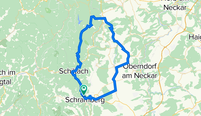
Landenbergerstraße 58/1, Schramberg nach Landenbergerstraße 58/1, Schramberg
A cycling route starting in Schramberg, Baden-Wurttemberg, Germany.
Overview
About this route
- 3 h 13 min
- Duration
- 71.4 km
- Distance
- 1,010 m
- Ascent
- 1,005 m
- Descent
- 22.2 km/h
- Avg. speed
- 748 m
- Max. altitude
Route quality
Waytypes & surfaces along the route
Waytypes
Busy road
38.3 km
(54 %)
Path
10.3 km
(14 %)
Surfaces
Paved
65.7 km
(92 %)
Unpaved
0.1 km
(<1 %)
Asphalt
65.2 km
(91 %)
Paved (undefined)
0.5 km
(<1 %)
Continue with Bikemap
Use, edit, or download this cycling route
You would like to ride Landenbergerstraße 58/1, Schramberg nach Landenbergerstraße 58/1, Schramberg or customize it for your own trip? Here is what you can do with this Bikemap route:
Free features
- Save this route as favorite or in collections
- Copy & plan your own version of this route
- Sync your route with Garmin or Wahoo
Premium features
Free trial for 3 days, or one-time payment. More about Bikemap Premium.
- Navigate this route on iOS & Android
- Export a GPX / KML file of this route
- Create your custom printout (try it for free)
- Download this route for offline navigation
Discover more Premium features.
Get Bikemap PremiumFrom our community
Other popular routes starting in Schramberg
 Von Trumpf Laser zum Weingut Herztal
- Distance
- 72 km
- Ascent
- 768 m
- Descent
- 1,276 m
- Location
- Schramberg, Baden-Wurttemberg, Germany
 Donau-Quellflüsse
- Distance
- 107.9 km
- Ascent
- 731 m
- Descent
- 748 m
- Location
- Schramberg, Baden-Wurttemberg, Germany
 Sulgen "Römerbad" Sulgen
- Distance
- 39.5 km
- Ascent
- 486 m
- Descent
- 456 m
- Location
- Schramberg, Baden-Wurttemberg, Germany
 Baron
Baron- Distance
- 56.5 km
- Ascent
- 44 m
- Descent
- 342 m
- Location
- Schramberg, Baden-Wurttemberg, Germany
 Zur größten Kuckucksuhr der Welt von Scharmberg
- Distance
- 51.6 km
- Ascent
- 1,436 m
- Descent
- 1,265 m
- Location
- Schramberg, Baden-Wurttemberg, Germany
 Sulgen Hardt Glasbachtal über Mariazell zurück
- Distance
- 32.8 km
- Ascent
- 293 m
- Descent
- 326 m
- Location
- Schramberg, Baden-Wurttemberg, Germany
 Feierabendrunde
- Distance
- 35.2 km
- Ascent
- 859 m
- Descent
- 859 m
- Location
- Schramberg, Baden-Wurttemberg, Germany
 Rund um Schramberg
- Distance
- 113.8 km
- Ascent
- 4,885 m
- Descent
- 4,633 m
- Location
- Schramberg, Baden-Wurttemberg, Germany
Open it in the app